Scenario Planning
This plan is a policy-focused document that employs a scenario planning process and modeling tool aimed at reducing guesswork and creating an objective base of knowledge for consciously creating a future Frederick County that embodies our values and aspirations. The scenario planning process allowed us to imagine a variety of possible futures and analyze the impacts and outcomes of those futures.
The scenario planning process is not simply about projections of data or linear views of the future. At its core, it is an endeavor in understanding how different forces interact and may help us create a future that is different from the system of land and community development in which developers, public officials, and communities have operated in since the rise of the automobile.
The scenarios described below are not rhetorical - they are not designed to show a predetermined preferred option in the best light. The scenarios are also not contingency plans - they are not intended to provide one course of action if one set of events occurs, and another equally valid set of options if a different set of event occurs. Rather, they are analytical. They allow us to think beyond the customary “predict and plan” approach and provide a means to explore four different, but not mutually exclusive, hypotheses about growth in the county. The outcomes of these scenarios are measurable and provide valuable information that informs our choices about how to grow.
The Livable Frederick scenario planning process is based on the premise that Frederick County’s growth and economic development is influenced by both regional and local dynamics, as well as changing market demands for both housing types and employment locations. Therefore one of the first steps in scenario development entailed an analysis of economic and growth trends in the greater Baltimore-Washington region. Specifically, this investigation included questions about the kinds of jobs, people, and households that would likely drive demand for growth in Frederick County over the next several decades. A second analysis was then conducted that involved examining how different growth patterns – scenarios of where new jobs and households may be located in Frederick County – could be influenced by various policy decisions, Our Vision, and other considerations. Finally, an outcomes analysis was conducted that examined a variety of impacts, such as differences between each scenario in accessibility, land consumption, and the satisfaction of the demand for different kinds of physical places.
The first analysis involved forecasting regional and local growth in order to derive a series of "control totals" for the number and type of jobs and housing that may occur in Frederick between the years 2015 and 2050. A forecasting method was employed that developed a picture of growth in Frederick County by examining trends in the broader Metropolitan Washington Council of Governments region in which Frederick County is located. A 2015 to 2050 increment of growth for jobs and housing was developed and became the basis for the analysis of various growth scenarios in the county. Notably, this forecast integrated an analysis of the physical, place-based preferences of different markets for jobs and housing.
A second analysis involved determining where the increment of growth - the forecasted new jobs and households in the county to 2050 – might be located based on the characteristics of physical places in a variety of scenarios. The centerpiece of this analysis is CorPlan, a GIS (Geographic Information Systems) based modeling tool developed by Renaissance Planning. More information about CorPlan can be found at Renaissance Planning's website here: http://www.citiesthatwork.com/corplan/.
Several scenarios were developed. First was a scenario that reflected development patterns that are currently in place and that are currently reflected in existing comprehensive plan policies referred to as the "Business As Usual." Then three other hypothetical scenarios were created which support the development patterns that align with the aspirational criteria of the vision and the demand characteristics of our forecasted growth. Specifically, these three scenarios each supported a different aspect of a multi-modal accessibility focused development pattern. These are "City Centers Rising," "Suburban Place-Making," and "Multi-Modal Places and Corridors."
Business As Usual
Maintains existing policies supporting land use, keeping our direction for future growth "as is." The future direction of growth in the county develops as a continuation of the current land use configuration following the pattern of past trends.
City Centers Rising
The City of Frederick and surrounding developed county land form a major urban, cultural, and activity center. Therefore, growth potential is maximized in and around the City to create even stronger places for walkable, urban living and working while retaining our sense of historic significance and connection.

Suburban Place-Making
Many of our residents love suburban living. Therefore, in this scenario, reinvestment is targeted toward existing suburban communities through infill development and redevelopment that creates additional opportunities to walk, shop, work, and recreate closer to home.
Multi-Modal Places and Corridors
Our county has existing infrastructure connections to the greater Baltimore-Washington Region, through rail service, transit operations, and major highways. In this scenario, these existing assets are leveraged to create multi-modal corridors that help catalyze the redevelopment of aging retail and office areas, while creating new mixed-use places in the southern part of the county.
Several baseline conditions established a resolute framework for the scenarios. First, pipeline development in the county and in our municipalities was allocated as currently approved for all of the scenarios. No scenario assumed any kind of alteration to pipeline development. Secondly, all Natural Resource designated lands (on the Comprehensive Plan Map) in the county, as well as any other significant natural features and working lands, were categorized into place types that limited the allocation of new development. As such, the pipeline of approved development, natural resource features, and working lands of the county were assumed to be substantially unaltered by the scenario analysis.
Outcomes
In the final step of the scenario planning process, the impact and outcomes for each scenario were analyzed. This involved estimating the impacts of new growth on our environment, economy, and transportation system. During this final step, the sensitivity of several indicators was evaluated relative to different growth scenarios. This informed decisions about the public policy direction that will support Our Vision. Some specific benchmarks that were considered include the following:
- Acreage of newly developed land
- Percent of new housing by type (housing choices)
- Acreage of agricultural lands consumed
- Energy consumption
- Acreage of green infrastructure impacted
- Air quality
- Percent redevelopment or infill
- Proximity to key destinations
- Attractiveness of new growth to different market segments (household types and job types)
- Percent of new development (housing and jobs) located in walkable, multi-modal centers
- Vehicle Miles Traveled (VMT) and mode split (percent auto vs. non-auto travel)
- A significant amount of the county's share of future household growth is likely to occur in currently planned developments known as the “pipeline growth.” However the traditional suburban patterns assumed with this growth may not be matching up with future market demands for greater housing choices and more walkable communities. Therefore, there may be an opportunity to revisit some of the assumptions associated with the pipeline development.
- Creating more multi-modal places and corridors (compact, walkable and transit-ready), positions the county well for different job sectors – but doesn’t noticeably change overall travel behavior in terms of reducing countywide Vehicle Miles Traveled (VMT) or use of non-auto modes (walking, biking, or transit) to get around. Therefore, there may be certain corridors or subareas of the county where new growth, infill or redevelopment could be targeted with more compact, mixed-use patterns supportive of a less auto-dependent lifestyle.
- Affordability of housing within the county will continue to be an issue with demand for wealthier households remaining high. Therefore, there may be specific opportunities where the county and its private-sector development partners can target production of more housing options with ample access to more transportation choices so that we can continue to attract the workforce needed for the creative economy, healthcare jobs, and other service industries.
- All of the scenarios intentionally push development away from sensitive natural resources, green infrastructure, and working lands. However, additional efforts may be needed to create greater incentives for contiguous natural spaces and working lands preservation.
- Infill development within our existing suburban neighborhoods can create more amenities located closer to where people live and provide more opportunities for walkable neighborhoods. There may be many opportunities for this type of infill development in the county.
- The creation of job centers within walkable, multi-modal areas is aligned with the workforce talent in the creative and high-tech industries. Therefore, there is opportunity to identify the best locations for future job centers that can achieve these types of development patterns.
The scenario process illuminated several key findings that ultimately can be incorporated into updates to the comprehensive plan. These include the following:
The Thematic Plan
The Thematic Plan derives its name from the fact that its purpose is to support the vision and its four vision themes of Our Community, Our Health, Our Economy, and Our Environment. The Thematic Plan represents a logical mix of the best ideas taken from each of the strategies explored during the scenario planning process, and provides a point of reference by which the county can find solutions to the challenges it faces in future years.
Each of the studied scenarios focuses on different approaches for improving multi-modal accessibility and providing transportation and housing choices for county citizens (with the exception of the “Business As Usual” scenario, which considered how the county might develop in future decades if current growth policies remained in place). This is the case for a number of reasons.
First, according to Metropolitan Washington Council of Governments (MWCOG) Round 9.0 Cooperative Forecasts (adopted in November 2016) 41,700 new households are projected to develop in the county and its municipalities between 2015 and 2045 (annualized to 1,345 new households per year). As of January 2019, the residential development pipeline for both the county and municipalities includes 21,348 available, with 11,789 located in the county's jurisdiction and 9,559 located in municipalities. This means that countywide (municipalities and county), about 59% of projected growth between 2019 and 2045 could be accommodated by existing approved pipeline dwellings. These pipeline dwellings are largely auto-oriented, single-family, suburban housing units, and while they could mathematically satisfy a significant share of the future demand for housing, this does not mean that planning efforts can be suspended until 2045. In fact, there is a pressing need and opportunity to augment this supply by supporting future development patterns that do not rely solely on automobiles for transportation.
Second, the scenario planning process revealed that there will likely be a significant shift in demand for places that are designed to support multi-modal accessibility. This trend is evident in both the employment and residential markets. Elements that will contribute to successfully meeting this demand include having retail, housing, and transit options in close proximity to places of work.
Third, importantly, is that the values and aspirations articulated in Our Vision and its four themes will be best supported by development patterns that foster multi-modal accessibility. For example:
Our Community is supported by multi-modal accessibility through encouraging housing that is serviced by transit to reduce transportation costs, and by ensuring that streets are walkable and accessible, fostering social interaction and reducing social isolation.
Our Health is supported by multi-modal accessibility by providing walkable neighborhoods that allow for active lifestyles and reduce reliance on the car, and by making services more accessible to those who need them.
Our Economy is supported by multi-modal accessibility by providing the types of walkable, accessible places in which workers are seeking to reside and that employers are seeking when they make location decisions. This will help make Frederick County communities primary centers of employment in the region, and will create the types of livable places our future workforce demands.
Our Environment is supported by multi-modal accessibility by reducing the number of vehicle miles traveled, supporting more efficient means of transportation, and by reducing the need for significant future expansion of development into rural and natural resource areas.
For these reasons, the overarching strategy of the Thematic Plan is to achieve a more multi-modal pattern of growth, while leveraging the existing pipeline of conventional suburban development. Therefore, the plan focuses on opportunities to enhance existing places, and create new places that are less auto-dependent, more walkable, bikable, and transit supportive, and that support progress toward commonly held goals of housing affordability, community health, transportation choice, environmental sustainability, and economic development.

What Is Multi-Modal Accessibility?
Multi-Modal vs. “Uni-Modal”
Today, the way we get from one place in our community to another is almost entirely by means of the automobile. Other ways of getting around such as walking, biking, or taking a type of public transit like buses and trains, are a distant second when it comes to the transportation choices we are able to make.
However there are other modes of transportation available, and for various reasons travelers often need or prefer travel by alternative modes. For example, many people cannot drive, including adolescents, older adults, people with disabilities, and people with economic challenges. Non-drivers therefore have less ability to access activities. Travelers may prefer alternative modes for exercise or enjoyment, such as walking or cycling, or for efficiency and stress reduction through the use of public transit.
Society could benefit from more efficient management of road space that favors higher “value” trips and more efficient travel modes in order to reduce traffic congestion, parking costs, accidents, and pollution emissions. If walking and cycling conditions, and public transit service quality were better, how much more would people rely on these modes, and how much less automobile travel would occur?
People would not likely be able to, or choose to, forego driving altogether. But there are indications that given better transport options and more efficient incentives, people would rationally choose to drive less, rely more on alternative modes, and be better off overall as a result.
For example, completing the sidewalk network in a typical U.S. town on average increases non-motorized travel 16% and reduces automobile travel 5%. Residents of transit-oriented communities tend to use alternative modes 2-10 times more frequently, and drive 10-30% fewer miles, than residents of automobile-oriented communities. Even larger travel reductions occur if improvements in alternative modes are implemented in conjunction with incentives such as more efficient road, parking and insurance pricing.
This indicates latent demand for alternative modes - a multimodal transportation approach. Many people would like to rely more on alternative modes but are constrained by poor walking and cycling conditions and inadequate public transit services.
Mobility vs. Accessibility
"Just as an automobile is a machine for mobility, a city is a machine for accessibility.”
Levinson, Krizek and Gillen 2005, excerpted from the Online TDM Encyclopedia published by the Victoria Transport
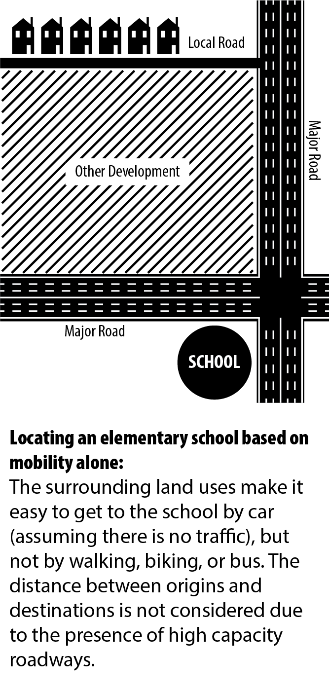
Access is the goal of any transportation system, and it can be argued that access is the central asset of developed areas, afforded by easy and widespread mobility. Mobility involves the efficient movement of people and goods by providing capacity and maximizing flow. Transportation that focuses on mobility is measured relative to capacity and flow.
From a mobility perspective, wider roads, more frequent transit service, and more sidewalks and pathways are the goals. However, a vital land use component, namely the relationship between origins and destinations, is not considered.
Accessibility encompasses the relationship between origins and destinations, and focuses on the ability to reach destinations, not on movement itself. If the goal of transportation is to increase access to destinations, and not simply to improve and perfect a single technology of transport, then greater consideration must be given to other forms of transportation and the land use patterns that they support.
Transportation accessibility is optimized with multimodal transportation and land use patterns that support more compact, mixed-use, walkable communities, which reduce the amount of travel required to reach destinations.

Growth Strategy
An important task of the Thematic Plan is the re-definition of the general growth strategy for the county such that it aligns with Our Vision. This plan’s growth strategy is proactive by identifying preferred portions of the county for locating growth, as well as attempting to capitalize on existing assets in the county that can play a significant role in efficiently meeting the demand for growth. The Thematic Plan represents a significant evolution of the “Community Concept” strategy historically used to structure growth in Frederick County.
Pipeline Development
As proposed, this redefinition of growth strategy will not directly affect approved pipeline development. The county has a significant supply of approved dwelling units, referred to as the residential development pipeline. Of the 33,060 previously approved dwellings and 21,348 available pipeline dwellings (as of January 2019), many have related Development Rights and Responsibilities Agreements (DRRA) that ensure their entitlements, including their zoning. The Livable Frederick Master Plan is not a vehicle for the reversal of these approvals.
However, this significant residential pipeline presents an opportunity to re-evaluate the county's general growth strategy for the long term without causing significant impacts in the short term. The fact that a significant share of projected growth can be absorbed by existing approved dwellings relieves some of the imminent pressure to plan for significant additional development capacity. Therefore, rather than focusing on modifying land use designations, highway classifications, and the location of community facilities on the Comprehensive Plan Map in order to plan for sufficient growth capacity, the pipeline affords us the time needed for a re-evaluation of how our overall growth strategy can support community aspirations and intentions.
This is not to suggest that the quest to align any possible disconnects between the development models employed in the pipeline and the development models advocated by the growth strategy is abandoned. As often occurs during the long time frames associated with large scale development, modifications to housing types, use mix, and neighborhood design naturally occur. It is possible that these "organic" modifications may trend toward a more multi-modal pattern of development, such as that supported by the LFMP, in order to be more competitive in the housing marketplace. In other words, conventional patterns of development may evolve over time to support market conditions that demand multi-modal accessibility.
The Community Concept
The Community Concept originated in the 1972 Frederick County Comprehensive Plan (1972 Plan), which described an overarching strategy for structuring growth referred to as the “environmental unit concept.” The 1972 Plan proposed a system where the county was divided into a nested mosaic of increasingly smaller geographic areas culminating in distinct but unified communities characterized by the centralized provision of facilities and community services. The proposed geographic structure included the following hierarchy of boundaries: the entire county; eight separate regions within the county; districts within each region; communities within each district; and, neighborhoods within each community.
Subsequent planning in Frederick County adhered to the provision of eight planning regions as a means of managing the planning process for the county's expansive geography. However, the remaining aspects of this environmental unit concept were translated into the notion of the Community Concept, which supports the concentration of growth in discrete areas largely served by existing infrastructure. This strategy provided correspondence with Maryland Smart Growth legislation that supported funding for infrastructure in defined growth areas.
The Community Concept came to describe a hierarchy of communities that was defined by population, residential density, intensity of commercial and employment uses, and level of community facilities, among other variables. The 2010 Comprehensive Plan began to move away from the Community Concept’s strict hierarchical structure, but preserved the basic strategy of focusing growth in specified compact areas, with some uniformity, throughout the county.
The Livable Frederick Master plan does not abandon the Community Concept strategy. However, it does support the continued evolution of its function in determining the structure of our growth. Instead of playing a singular and central role, the Community Concept is retained as an underlying strategy that augments the Thematic Plan and is specifically identified within the Secondary Growth Sector. The underlying notion of compact development around existing communities, supported by the Community Concept, remains. In addition, the Community Concept continues to function as a centerpiece of the strategy of supporting growth within existing municipalities.
Planning Sectors
The Thematic Plan is composed of four planning sectors, which are heavily influenced by the three scenarios-based growth strategies of “City Centers Rising”, “Suburban Place-Making”, and “Multi-Modal Places and Corridors.” They are: the Primary Growth Sector, the Secondary Growth Sector, the Agricultural Infrastructure Sector, and the Green Infrastructure Sector. The identification of these four sectors is intended to provide a distinction based more on category than on rank. Each sector has differing priorities, however all four of them play an equally vital role in the support of livability in Frederick County.
Planning Sectors, and their related subcategories described below, function as an overlay to the existing practice of designating Community Growth Areas. As delineated on the Comprehensive Plan Map, and as described in the Comprehensive Plan Map section of this plan, Community Growth Areas continue to be employed as a central aspect of our comprehensive planning.
The function of growth areas is to define an outer limit to the expansion of development into rural land. While they function well as a means of communicating a binary distinction between areas in the county targeted for growth versus areas that are not, they do not serve as a mechanism for identifying and articulating multi-level and vision-based aspirations or strategies related to growth. They do not explicitly identify growth areas that are better suited to support the vision and strategic objectives of the county.
The Thematic Plan functions as an expression of priorities for creating the types of places that will support Our Vision. This is accomplished, in part, by defining preferred development models tied to specific areas. The Thematic Plan references selective community growth areas identified on the Comprehensive Plan Map as a means of prioritizing growth strategies, as well as defining preferred growth patterns connected to specific growth areas.
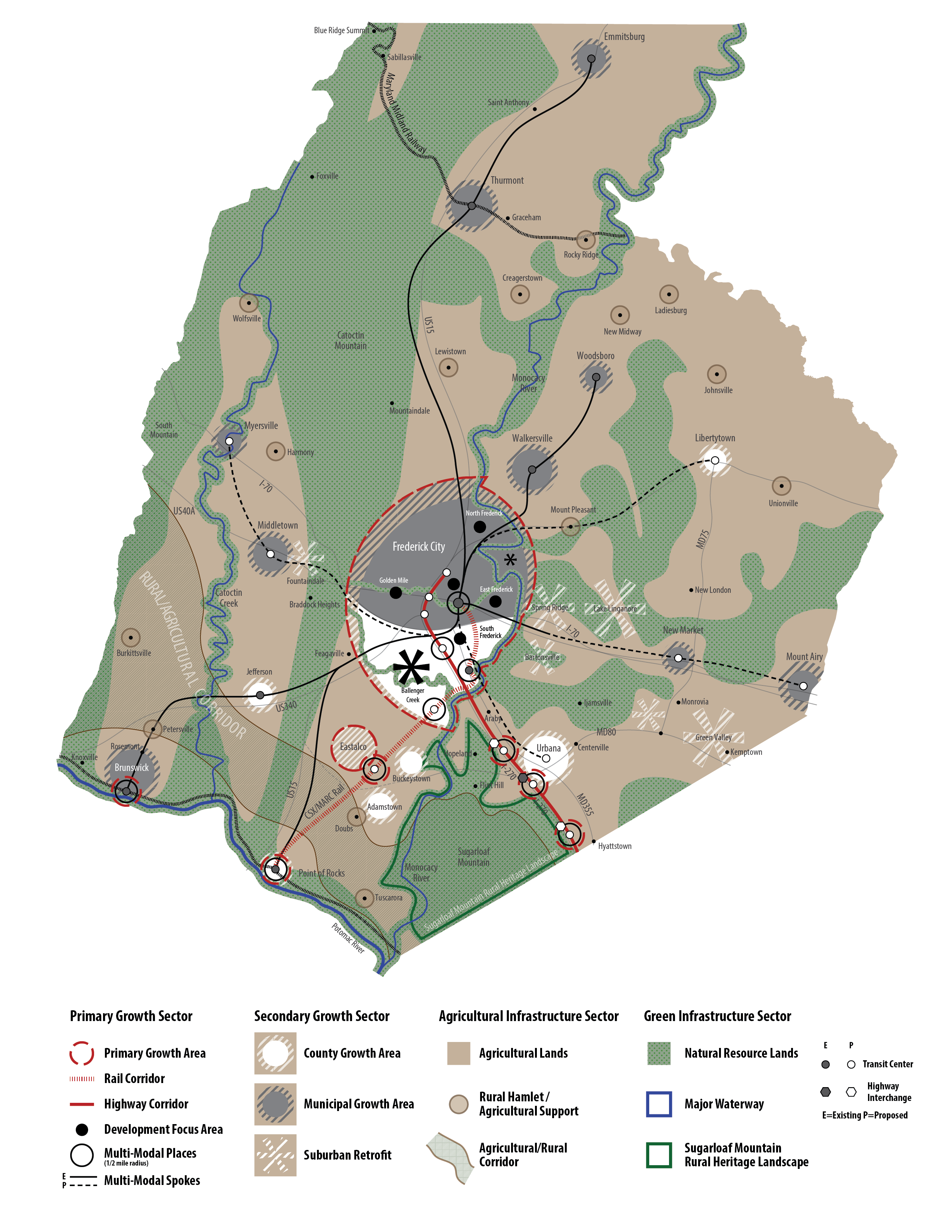
The Primary Growth Sector
The Primary Growth Sector articulates the locations and types of development that are to be emphasized as the county grows in future years. Given the significant existing pipeline of development, as well as the cumulative land area surrounding and within existing communities throughout the county that is currently designated in the Comprehensive Plan Map, the Primary Growth Sector may not correspond to locations where the majority of our future county-wide growth will be directed. Therefore, a basic purpose of the Primary Growth Sector is to support the long term strategic shift in the style and location of development that will occur in Frederick County.
The Primary Growth Sector is composed of land in and around Frederick City, including the Frederick City Growth Area, the Ballenger Creek Community Growth Area, the South Frederick Community Growth Area, and lands along major infrastructure corridors in the southern portion of the county that connect to regional employment centers. These areas include the Eastalco Growth Area, the Brunswick Community Growth Area, the Point of Rocks Community Growth Area, the Urbana Community Growth Area, and the I-270 Growth Area.
Two districts are identified within the Primary Growth Sector: the Central District and the Multi-Modal District. The Central District is composed of major developed areas in the county that have significant access to infrastructure and services - areas where there is high potential for development patterns that support multi-modal accessibility, and where a significant share of development may occur through infill and redevelopment strategies. The Multi-Modal District includes specific corridors in the county where growth potential will be maximized by leveraging the existing assets of rail and highway infrastructure that connect Frederick County to the greater Baltimore-Washington region. Emphasis is on building transit connectivity, centered on the City of Frederick, and creating multi-modal corridors that catalyze redevelopment of aging retail and office developments, while also creating new transit accessible mixed-use locations in the county.
Central District:
The Central District (see Figure 1) includes areas in and around the City of Frederick where future growth potential will be maximized through new development, redevelopment, and annexation, as well as areas outside of the city to the south in Ballenger Creek and South Frederick, including the South Frederick Triangle (the 85/355 Corridor). Emphasis for development is on strengthening places that support walkable, mixed use, urban living, while retaining a sense of place.
Figure 1: The Central District
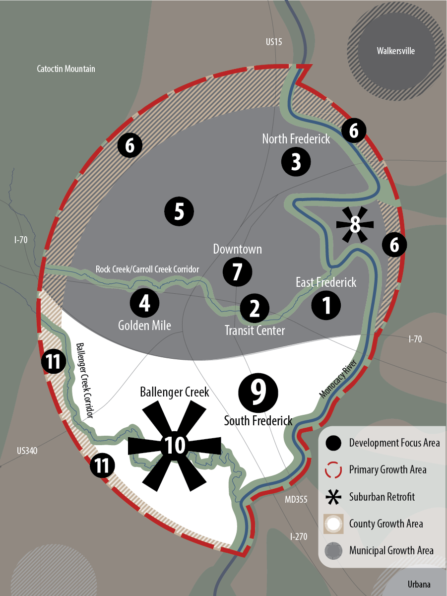
- 1) East Frederick (Nicodemus, Renn, et. al.)
- 2) Downtown Frederick Transit Center (MARC and TransIT)
- 3) North Frederick (Market Square, Monocacy Center, Spring Bank, Bowersox, et. al.)
- 4) Golden Mile (Rt. 40) Redevelopment
- 5) Infill development throughout Frederick City
- 6) Annexation of Frederick City
- 7) Downtown Frederick City
- 8) Monocacy Boulevard Retrofit
- 9) South Frederick Triangle Redevelopment
- 10) Ballenger Creek Retrofit
- 11) Expansion of Ballenger Creek Growth Boundary
The City of Frederick
Specific growth locations within the City of Frederick have been identified in partnership with the city and generally align with their plans for future growth. Their inclusion in the Thematic Plan does not imply that Frederick County is advocating for an extension of county planning jurisdiction over Frederick City. Rather, the Thematic Plan is intended to reinforce the cooperative relationship between Frederick City and the county.
These locations include redevelopment of industrial uses and new greenfield development in East Frederick (1), transit-oriented development around the existing Frederick MARC Station (2), continued development in North Frederick (3), redevelopment along Route 40 - the “Golden Mile” (4), infill development throughout the city (5), and limited greenfield development through annexation around the city (6). Additionally, a development focus area is identified within Downtown Frederick City (7), which will certainly take primary form as infill and redevelopment. Finally, a suburban retrofit strategy may be possible within the industrial uses along the Monocacy Boulevard corridor. (8)
The South Frederick Triangle
The South Frederick Growth Area (a.k.a. Frederick Southeast Growth Area) (9) is located to the south of Frederick City and bounded by I-270, I-70, and MD 144. This is a predominantly commercial and industrial area that includes the county’s largest regional mall, corporate offices, industrial uses including a limestone quarry, and a MARC commuter rail station. Within this growth area, centered on MD85 and MD355, is the South Frederick Triangle (also referred to as the 85/355 Corridor).
Redevelopment is the primary mechanism for absorbing growth within the South Frederick Triangle. This is because the area has many advantages of infrastructure and location that can support higher density, mixed use development, as well as the fact that trends and forecasts support the relatively quick transition of land uses associated with the types of large scale commercial uses that exist in this area.
Development in the South Frederick Triangle will emphasize mixed-use development with the introduction of a significant number of residential dwellings and will focus on accentuating public space and walkability attributes. This will occur primarily through the redevelopment of existing commercial uses as they approach obsolescence. While transit-oriented development is supported in the vicinity of the existing MARC Station (see the discussion of the Multi-Modal District below), the extent of consideration for redevelopment will encompass the entire South Frederick Triangle. The scope of consideration for the redevelopment of this area will help realize its potential to become a far more urbanized landscape supporting proximity to jobs, services, and transportation options such as walking, biking, and transit.
Ballenger Creek
The Ballenger Creek Growth Area (10) is located to the south of Frederick City and is composed of a fragmented combination of employment, industrial, and residential uses. Residential use is predominant. In terms of the conversion of rural land to urban/suburban land, this growth area is largely built out. Currently, there are very few remaining "vacant" or undeveloped parcels of land in this area.
Therefore, while Ballenger Creek is identified as being within the Primary Growth Sector, emphasis in this area will be on a suburban retrofit growth strategy. This will include a focus on making the existing infrastructure more multi-modal, providing new infrastructure where needed to support multi-modal accessibility, and finding opportunities for higher density redevelopment - especially in the form of mixed-use opportunities in existing commercial areas. Additionally, limited extension of the Ballenger Creek Growth Area may occur (11).
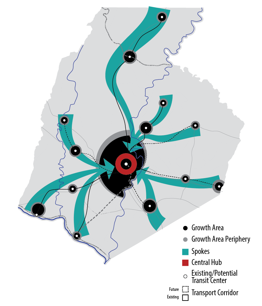
Hub and Spokes
Development of the Central District will be leveraged by supporting a "hub-spoke" structural relationship between the Central District and the surrounding municipal and non-municipal communities throughout the county (Figure 2). This involves supporting the role of the Central District as a county "hub" where the flow of people accessing goods and services occurs along several "spokes" that emanate from the Central District and connect to surrounding, outlying communities. This strategy achieves a form that supports multi-modal accessibility through implementing this "spoke-hub" model as a transit distribution strategy. This is a way of distributing transit service in which routes are organized as a series of "spokes" that connect outlying points (transit centers within communities) to a central "hub" (the Central District). This approach can reinforce primary growth in the central portion of the county, while supporting activity and secondary growth in surrounding communities.
Figure 2: Spoke Hub Distribution
Multi-Modal District:
The Rail Corridor
The Rail Corridor represents a concentration of growth within a development corridor in the southern portion of the county along the existing CSX/MARC rail line that runs from the Downtown Frederick Transit Center to Point of Rocks (Figure 3). Growth along the Rail Corridor will occur in the form new development and redevelopment in a transit-oriented, mixed-use fashion. The existing Monocacy MARC Station, located behind the Riverview Plaza on MD 355, provides an opportune location for such future development.
Figure 3: The Rail Corridor
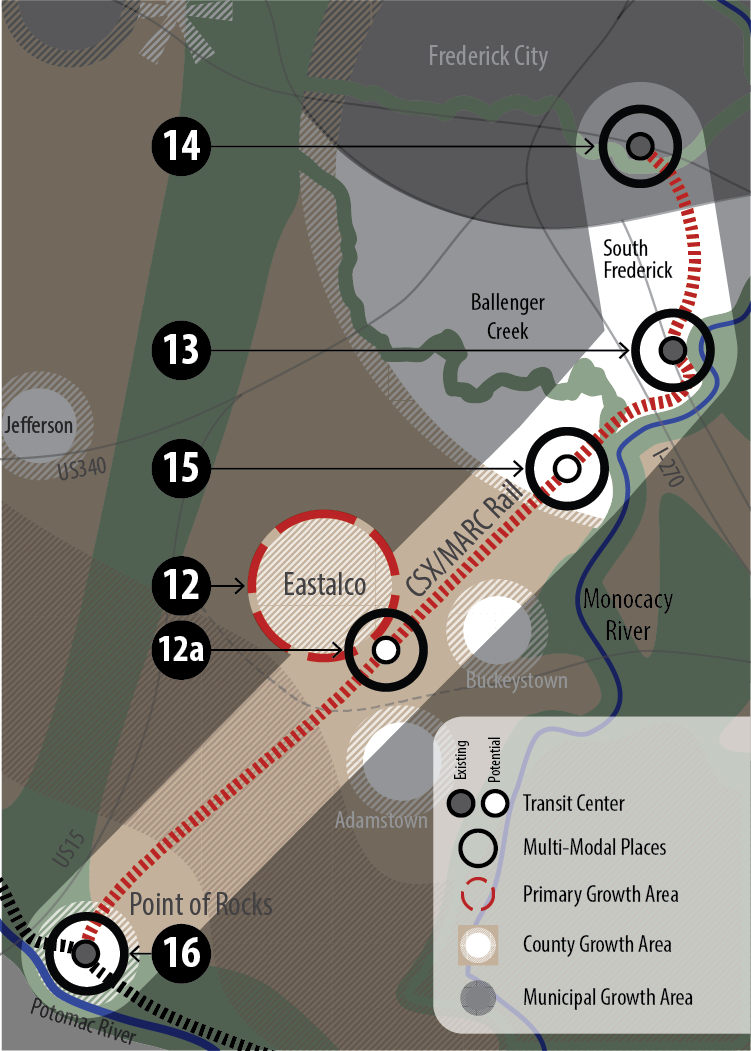
- 12) Eastalco Growth Area
- 12a) Multi-Modal Development Surrounding Potential New MARC Station
- 13) South Frederick Triangle Redevelopment and Multi-Modal Center
- 14) Downtown Frederick Transit Center (MARC and TransIT)
- 15) Potential Multi-Modal Development Within Ballenger Creek East
- 16) Potential Multi-Modal Development in Point of Rocks in Proximity to Train Station
- Not shown: Brunswick City Multi-Modal Development
Eastalco Growth Area
A continuing focal point for development is identified in the area surrounding the decommissioned “Eastalco” site (12) (identified as the Eastalco Employment Area in the 2010 plan, and including, but not limited to, land holdings of the former Alcoa aluminum refinery and production plant located along Manor Woods Road between New Design Road and Ballenger Creek Pike). This area is currently the largest concentration of undeveloped land in the county zoned for general and/or light industrial development and presents a unique opportunity for future development.
The opportunity for future development at points along this corridor – including the Eastalco site, South Frederick (13, 15), and Point of Rocks (16) – will be assessed and considered carefully during the development of small area plans for each of these places. While each small area plan will involve a study of those attributes and limitations unique to that growth area, many of the assessments will be similar in scope.
For the Eastalco Growth Area, overarching development issues and opportunities would require a detailed assessment of the following elements as part of a future community planning effort, including:
- A community outreach component that will include a citizens advisory group or similar entity to ensure broad community engagement;
- A preservation component to include a review of historic sites and archaeological resources, viewsheds and cultural characteristics (identification, documentation, and preservation when appropriate), including special consideration of structures and sites associated with Charles Carroll of Carrollton Manor;
- An infrastructure component that identifies the timing and funding of public facilities (including roads and schools) necessary to support the efficient development of the designated growth area;
- A comprehensive study to address MARC system access and expandability with input from Maryland Transit Authority, County Transit, and CSX;
- A green infrastructure component that includes a detailed review of environmental systems and resources (hydrology, forests, habitat assessment), and that integrates the built environment to the natural edges, through the placement and programming of open space and additional preservation areas;
- An agricultural preservation component that examines options to encourage preservation of the valuable farmland at the site, as well as in the surrounding Priority Preservation Area;
- A thorough, transparent and open study of industrial site contamination and subsequent post-industrial remediation and monitoring efforts, in consultation with Maryland Department of the Environment and the Environmental Protection Agency;
- An assessment of the potential land use mix, which could include business, retail, residential, industrial, agricultural, open space, recreational, and institutional uses, for the growth area, including physical design, neighborhood impacts, public facility adequacy, comparative analysis of alternate land use scenarios, unique opportunities to address countywide planning challenges, and development feasibility;
- And finally, a thorough examination of how this existing growth area fits into the larger planning context for Frederick County, addressing countywide growth projections, current and future transportation challenges, and community efforts to plan effectively, consistently, and in a coordinated manner, for the Frederick County of tomorrow.
Monocacy MARC Station
A second focal point for growth is the South Frederick Triangle (or the 85/355 Corridor) (13), particularly the area surrounding the existing MARC station. This location represents another example of the best options for growing in a manner that preserves our rural land and that supports multi-modal accessibility. Its current incarnation as a suburban center for commercial retail and office belies it's potential to be redeveloped in a more urban fashion, one that can create a new city-like environment, centered around the existing Monocacy MARC Station, and that includes residential development.
Few areas in the county are endowed with the degree of infrastructure investment that exists within the South Frederick Triangle. Yet the intensity of development is relatively minimal, constrained as it is by the emphasis on auto-centric design formats, among other factors. With proper planning, this area could become a vital urban environment that is on par with, yet distinct from, Downtown Frederick City.
Downtown Frederick Transit Center
The Downtown Frederick Transit Center (14) is located within Frederick City near the intersection of East Street and Patrick Street. It currently serves as a transit center for the county’s TransIT bus service and MARC commuter rail. Access to the TransIT Station and MARC Stations, adjacent vacant land, adjacent underutilized land, and redevelopment potential mark the area of Frederick City surrounding the Downtown Frederick Transit Center as having high potential for transit oriented development.
South Ballenger Creek
The South Ballenger Creek area is located within the southern portion of the Ballenger Creek Community Growth Area. This land is characterized by low density industrial and employment development with some residential development to the north. Notably, the CSX/MARC Rail Line runs through this area. South Ballenger Creek may present opportunities for innovative forms of development, both transit-oriented and rail-oriented, that support multi-modal accessibility (15).
Brunswick
The Brunswick Community Growth Area is the largest growth area in the Brunswick Region. As a hub for the Baltimore and Ohio Railroad in the late19th century and through the first half of the 20th century, the town flourished until railroad operations were reduced in the 1950’s. Modern day Brunswick City functions as a commuter hub for Washington, D.C. The downtown area is designated a Main Street community with a growing mix of businesses and residential uses. With a combination of steeply sloping topography, direct adjacency to the Potomac River, active rail operations, and historic building stock, the City of Brunswick possesses a physical character and atmosphere that is decidedly unique in Frederick County.
Point of Rocks
Point of Rocks is an unincorporated community located along the Potomac River at the junction of MD 28 and US 15 (16). It contains some commercial, industrial, and retail uses. The majority of the community is composed of several major residential subdivisions. Most notably, the community contains an existing MARC Station.
Much of the Point of Rocks Community Growth Area is developed in the form of low density, suburban residential subdivisions. However, opportunities for higher density mixed use redevelopment may exist within proximity to the MARC Station, while accounting for the significant surrounding floodplain. Therefore, emphasis for growth within the Point of Rocks community will be on transit-oriented, mixed-use development, focused on leveraging the presence of the MARC station.
The Interstate Corridor
The Thematic Plan Diagram identifies a corridor for growth and development along Interstate 270 leading from central Frederick City, through the Ballenger Creek Community Growth Area, and continuing along I-270 through the Urbana Community Growth Area and terminating at the northern edge of Hyattstown (Figure 4). This corridor emphasizes transit-oriented, mixed-use development to be served by a practical and affordable transit line (e.g., Bus Rapid Transit, Transitway) (17) that parallels Interstate 270 and takes advantage of public and private infrastructure improvements extended to the Urbana Community Growth Area in recent decades. Additionally, the Interstate Corridor will continue to capitalize on significant access to regional employment centers by supporting policies that facilitate the development of this area as a prime employment corridor enhanced by livable, mixed-use neighborhoods between the City of Frederick and northern Montgomery County.
Figure 4: The Interstate Corridor
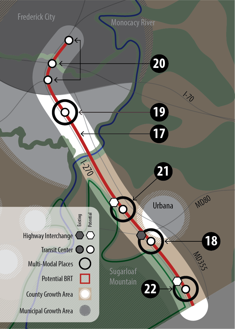
- 17) Potential Future Mass Transit Corridor
- 18) Urbana Multi-modal Development Surrounding Potential New Transit Station
- 19) Potential Multi-Modal Development at Future Mass Transit Station
- 20) Potential Future Mass Transit Stations
- 21) Potential Multi-Modal Development at Future Mass Transit Station
- 22) Potential Multi-Modal Development at Future Mass Transit Station
Highway Interchanges
Development along this corridor is identified as transit-oriented centers primarily located at existing and planned future highway interchanges. This will occur in concert with the development of transit station locations in order to encourage multi-modal accessibility and a pedestrian-oriented growth pattern.
In and around the Urbana Community Growth Area, there is one existing interchange at I-270 and Fingerboard Road (MD80) (18), and there are two planned interchanges at I-270 and Park Mills Road (21) and I-270 and Doctor Perry/Mott Road (22). As a future transit line along I-270 comes to fruition, highway interchanges will function as natural locations for creating future transit stops and corollary transit-oriented development.
Within Frederick City, there are a number of existing highway interchanges along US15 (20). Given the existing concentration of development and walkability available within Frederick City, any of these locations may be suitable for future transit stops associated with a transit line along I-270.
Finally, as planning for the South Frederick Growth Area continues, the passage of I-270 through this area suggests that there may be long-term opportunities for the creation of an additional transit stop. This will take the form of walkable, mixed-use, higher density development, and will be integrated into future plans for this area (19).
The Secondary Growth Sector
As mentioned above, the identification of the four Sectors is intended to be a distinction of category rather than rank. It is important that all of the communities in the county provide the support and infrastructure needed to meet the demands of growth and conservation, and to develop in a fashion that is sanctioned by all those affected. However, the distinction between the Primary and Secondary Growth Sectors does involve some prioritization.
This is due to the fact that it is a central strategy of this plan to support multi-modal accessibility, and to leverage this by focusing on areas within the county that have significant existing infrastructure, such as Frederick City, the CSX Rail Line, and Interstate 270. This existing infrastructure is concentrated in the southeastern portion of the county, which will be under the greatest pressure for new growth and development due to its proximity to Washington D.C. and urbanized areas within Montgomery County. Therefore, a priority has been placed on those areas that can support the core strategy of the LFMP and that are under the greatest pressure for growth.
However, this is not meant to imply a lack of support of the continued ability of other areas within the county, especially our municipalities, to grow and develop. As described below, two types of districts within the Secondary Growth Sector have been identified to provide a framework for the continued growth and development of these areas of the county.
Figure 5: The Secondary Growth Sector
Retrofit Districts
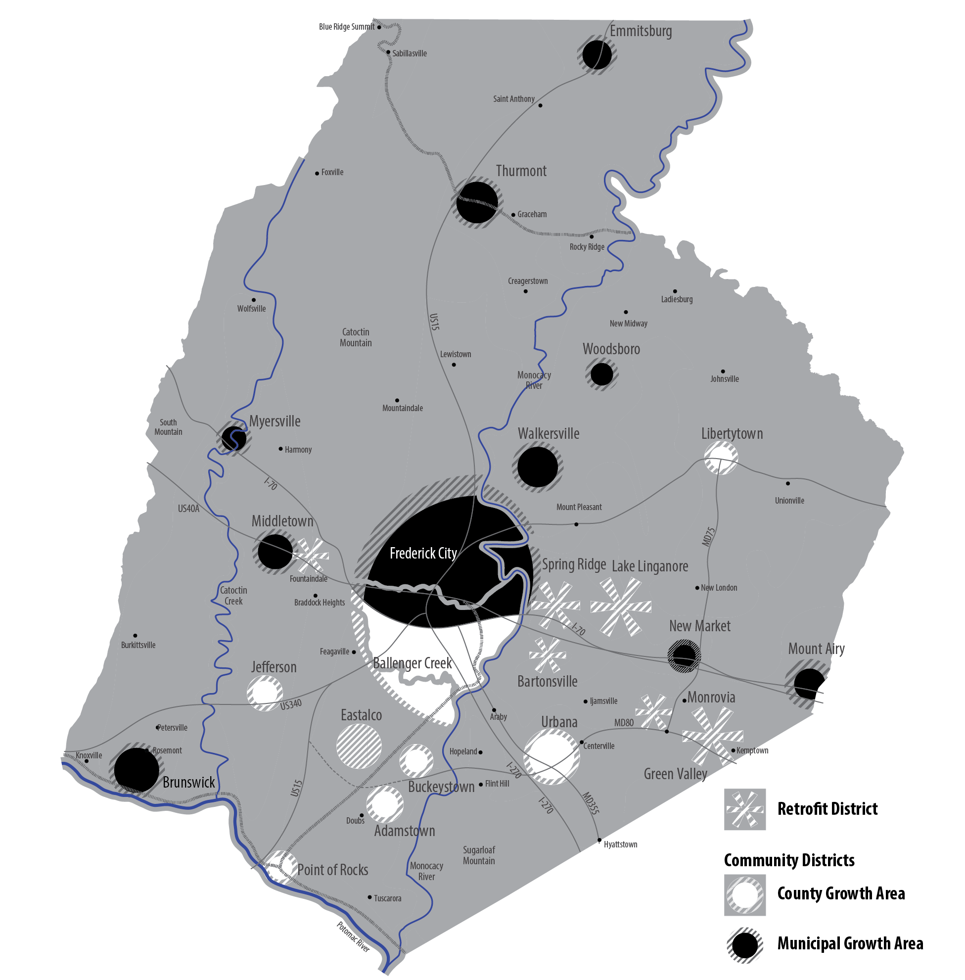
A community value to minimize the conversion of rural land to suburban/urban land, the rising preference for walkable, mixed-use places, the dwindling availability of major greenfield sites, a potential escalation in the number of vacant "greyfield" properties, and the presence of a number of older and conventional suburban developments in the county that could be made more walkable and could include small areas of mixed-use, are all factoring into the potential that one of the next major development projects in the county in the coming decades will be the retrofitting of our suburbs. Retrofit Districts are intended to support and improve existing suburbs to make suburban communities stronger by reinvesting in them with infill development and redevelopment that creates more opportunities to walk, shop, work and recreate closer to home. (Figure 5).
Retrofit Districts can include: the coordinated funding and construction of sidewalks; finding opportunities for road diets and complete streets; improving bikability; finding locations for mixed-use; and, making development more ecologically sustainable. Specific strategies involved in planning for Retrofit Districts will be identified in community or corridor plans. Some potential Retrofit District locations include Ballenger Creek, Fountaindale, Lake Linganore, Spring Ridge, Bartonsville, and Green Valley.
Community Districts
As described above, the Community Concept is the growth strategy that has historically guided and structured growth in the county. Community Districts are the continuation of the traditional Community Concept strategy of directing growth into existing communities, many of which are municipalities, that are served with water and sewer. In fact, this approach continues as the underlying strategy for all growth and development in the county.
Community Districts align with the many Community Growth Areas identified on the Comprehensive Plan Map. Most of these growth areas are designated around the many existing municipalities in the county. They focus on the creation of distinct places that: keep agricultural and natural landscapes intact; maintain safe, healthy, and vital neighborhoods; provide robust systems of public infrastructure; provide ample and convenient connections to parks, trails and natural landscapes; and, ensure excellence in design and efficiency.
Inherent to Community Districts is the intent that a share of future growth and development will continue to occur within and around existing communities and municipalities. Cities, towns, and unincorporated places will continue to grow and thrive with new growth and redevelopment opportunities.
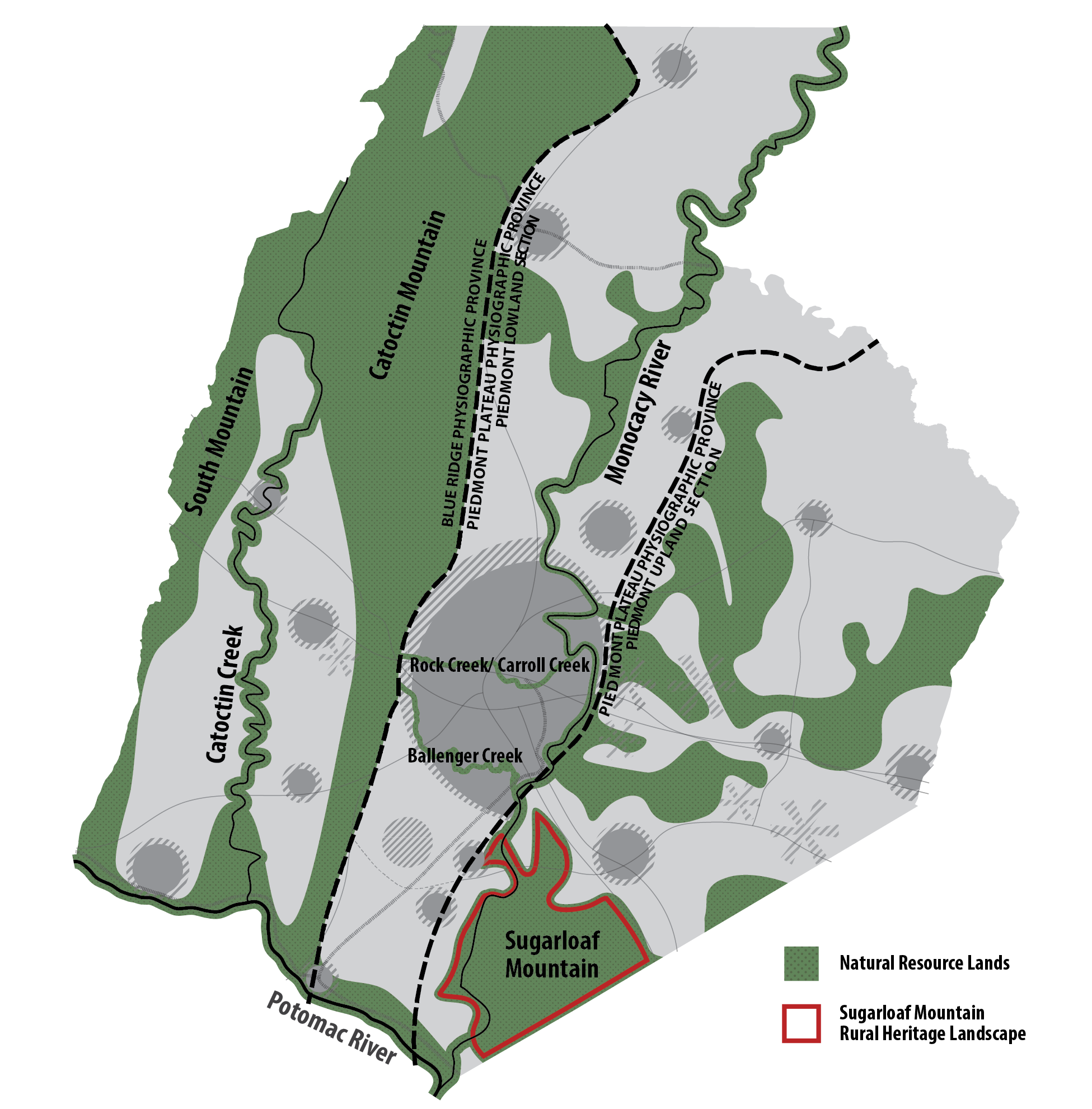
The Green Infrastructure Sector
As the amount of developed land has increased, natural areas have not only decreased in quality and quantity, but have undergone significant fragmentation. Locally, this can negatively impact the vitality of the ecosystem and the health and happiness of county residents. At a regional and state level, the ability of Frederick County to protect its green infrastructure will benefit the Potomac River and the Chesapeake Bay. The Green Infrastructure Sector is therefore identified to support the conservation of natural resources and environmentally sensitive areas in the county, to direct urban/suburban growth away from green infrastructure and sensitive areas, and to ensure the protection and integration of green infrastructure where it exists within areas targeted for growth. (Figure 6) This sector will be further implemented through the development of a Livable Frederick Green Infrastructure Sector Plan.
The Green Infrastructure Sector can include two components: the green infrastructure network, and environmentally sensitive areas (and potentially others, such as energy). Green infrastructure networks contain a wide variety of natural features, but are composed primarily of two components, hubs and links. Environmentally sensitive areas often overlap but may also occur outside of identified green infrastructure networks.
Figure 6: The Green Infrastructure Sector
Green Infrastructure Network
Within a green infrastructure network, hubs are defined as large, ecologically significant natural areas that provide habitat for animal and plant species that cannot thrive in small patches of forest or meadow. They are large enough to provide a functional habitat for species that forage over large areas and heterogeneous enough to satisfy the unique habitat requirements of species that are specialized to particular environmental niches. Links, or corridors, are linear configurations of natural lands such as forested stream valleys and mountain ridges that allow animals and plant life (seeds, pollen, spores, corms) to move from one area to another, linking hubs together. Links and corridors function to connect isolated hubs of wildlife habitat that have been fragmented by development or agriculture.
The Maryland Department of Natural Resources (MD DNR) prepared a Green Infrastructure Atlas and a Statewide Green Infrastructure Assessment in 2006. These identified large, contiguous blocks of ecologically significant natural areas and corridors with which to maintain or create a statewide network of natural resource lands.
The development of a county green infrastructure network must: enhance and complement the statewide network; identify gaps in a green infrastructure network and strategies to fill the gaps; identify and highlight the county’s natural resources and sensitive areas to garner support for - and generate - protective measures; support the achievement of state and county natural resource conservation goals; support the desired development pattern of the county described in the Livable Frederick Master Plan; and, facilitate Maryland's Smart Growth policies.
While green infrastructure networks may contain a wide variety of environmentally sensitive resources, their primary natural features are mountains, forestlands, wetlands, and stream valleys. These function together to conserve the natural ecosystem, sustain clean air and water, and provide a wide array of benefits to people and wildlife, such as: storing and cycling nutrients; filtering and cooling water in streams and aquifers; conserving and generating soils; pollinating crops and other plants; sequestering carbon and purifying the air; protecting areas against storm and flood damage; and, providing wildlife habitat.
Forests: The majority of the forest in Frederick County is located on Catoctin Mountain, South Mountain, Sugarloaf Mountain, and within the Monocacy Natural Resources Management Area. Other areas in the county are also identified on the State’s Green Infrastructure Atlas. However, many other much smaller forested tracts exist in isolated patches scattered throughout the county and some county forest cover located within certain stream corridors are not included in the State Green infrastructure Atlas.
Mountains: There are three mountain areas in Frederick County. They are Catoctin Mountain, South Mountain, and Sugarloaf Mountain. The Catoctin Mountain runs north south in the west-central part of the county and South Mountain runs along the boundary with Washington County. Sugarloaf Mountain is located in the southern part of the county along the boundary with Montgomery County.
Stream Valleys: Three major stream valley systems comprise this portion of the county’s Green Infrastructure; the Potomac River, the Monocacy River, and Catoctin Creek. Other stream valley resources include the thousands of miles of streams and their associated wetlands and floodplains throughout the county.
Parkland/Protected Lands: Frederick County has over 28,000 acres of land under public ownership in various park and open space uses. The following types of protected lands are included in the county’s green infrastructure network: federal parks; state parks and natural resource lands; county regional and district parks; municipal owned watershed properties; privately owned lands with MET easements, which are adjacent to other resources; and, significant privately owned lands with protection, such as Sugarloaf Mountain (Stronghold Inc.).

Environmentally Sensitive Areas
Environmentally sensitive areas may occur within or outside of areas identified as being within a green infrastructure network. These include environmental features identified under Md. LAND USE Code Ann. § 1-101, which describes the Sensitive Areas Element of Comprehensive Plans.
Streams and Stream Buffers
Streams are grouped into a hierarchical system—first order, second order, third order, etc.—from the smallest headwater stream to the Monocacy and Potomac Rivers in Frederick County. Streams and their buffers perform a wide variety of functions and have numerous environmental benefits. The buffer or riparian area of a stream is part of the stream ecosystem whose boundaries often depend on conditions of slope, soil, ground cover, and hydrology. The buffer encompasses parts of the stream ecosystem that are often dry, yet integral to the stream’s health. Stream buffers include:
- Floodplains, where most stream wetlands are located and where energy dissipation, natural filtration, floodwater storage occur.
- Stream banks and adjoining steep slopes that help to prevent erosion from clogging the streambed and provide plant and animal habitat.
- Streamside forests, which provide habitat, stabilize banks, provide shading, control temperatures, filter pollutants and produce leaf-litter, which supports a variety of aquatic organisms.
Stream Use Designations
The federal Clean Water Act requires states to develop water quality standards to protect and improve surface waters. These standards are based on a particular water body use, function, goal or “designated use,” such as supporting trout populations or protecting public water supplies. Criteria to support these designated uses include specific limits or amounts of dissolved oxygen, bacteria, temperatures, toxics, and turbidity (clarity) in the particular stream. The State of Maryland has defined designated uses of surface waters as shown below:
High Quality (Tier II) Waters
Tier II waters indicate exceptional water quality, in-stream and riparian habitat conditions as measured by the health of the biological community—fish and insects—in a stream. In order to be classified as Tier II, waterways must have high values in the following measures of biological health:
- Fish Index of Biotic Integrity (FIBI) – a measurement of the composition, diversity, pollution tolerance, habitat, and feeding characteristics of fish.
- Benthic Index of Biotic Integrity (BIBI) – a measurement of the composition, diversity, pollution tolerance, habitat and feeding characteristics of stream insects, called benthic macro invertebrates.
Four stream segments and their watersheds in Frederick County have been identified by the State as high quality Tier II waters: Big Hunting Creek, High Run, Weldon Creek, and an un-named tributary to Talbot Branch.
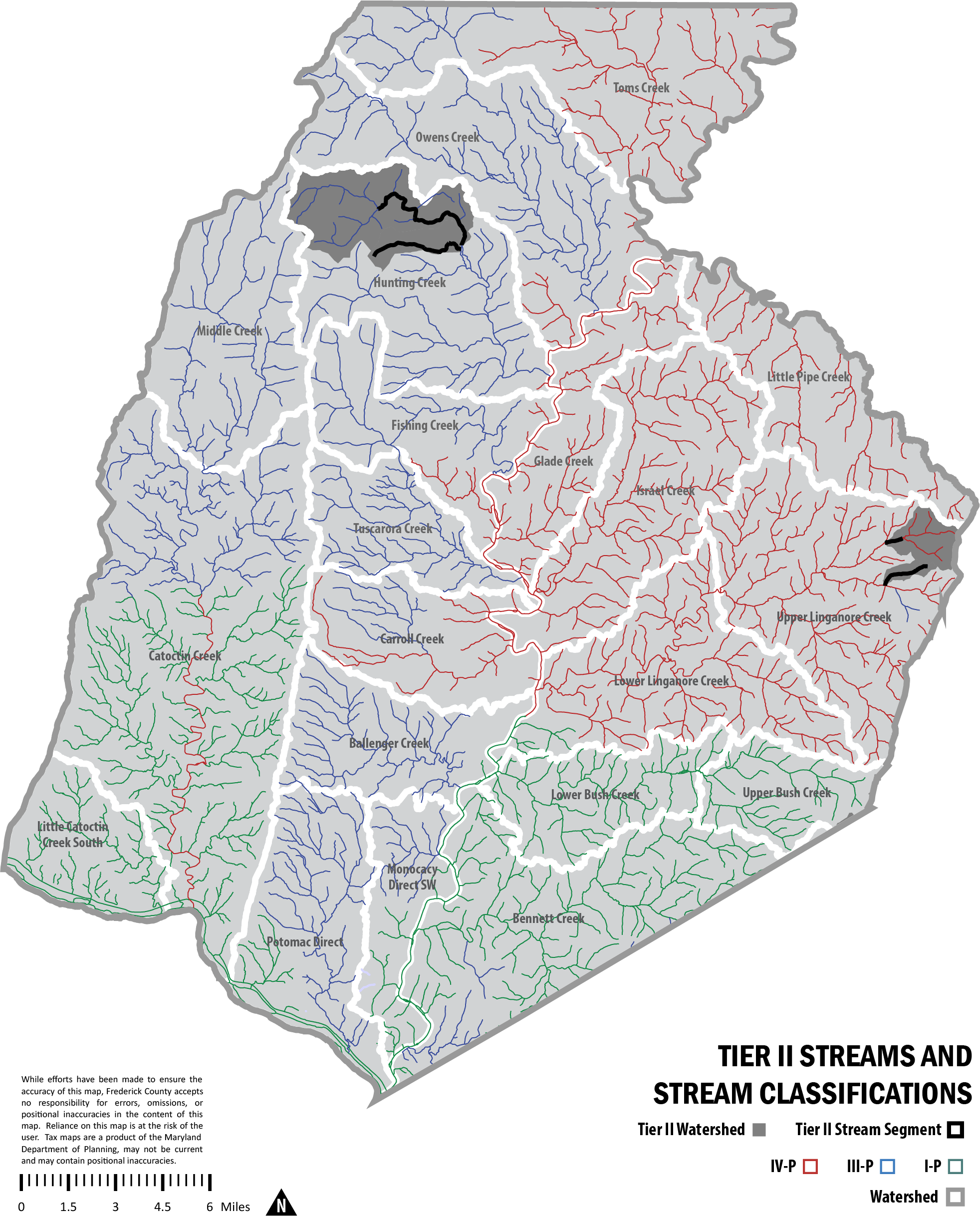
To protect these high quality Tier II waters, the State has adopted an anti-degradation policy and regulatory protections. To implement this policy, state regulations require a Tier II anti-degradation review be performed if proposals for wastewater, stormwater or other discharges result in a new discharge or modifications of an existing discharge into Tier II waters. The regulations also apply to discharges in the watershed located upstream of identified Tier II segments in order to protect downstream water quality. The Maryland Department of the Environment’s Water Quality Infrastructure Program is responsible for coordinating the review of applications for discharges into Tier II waters.
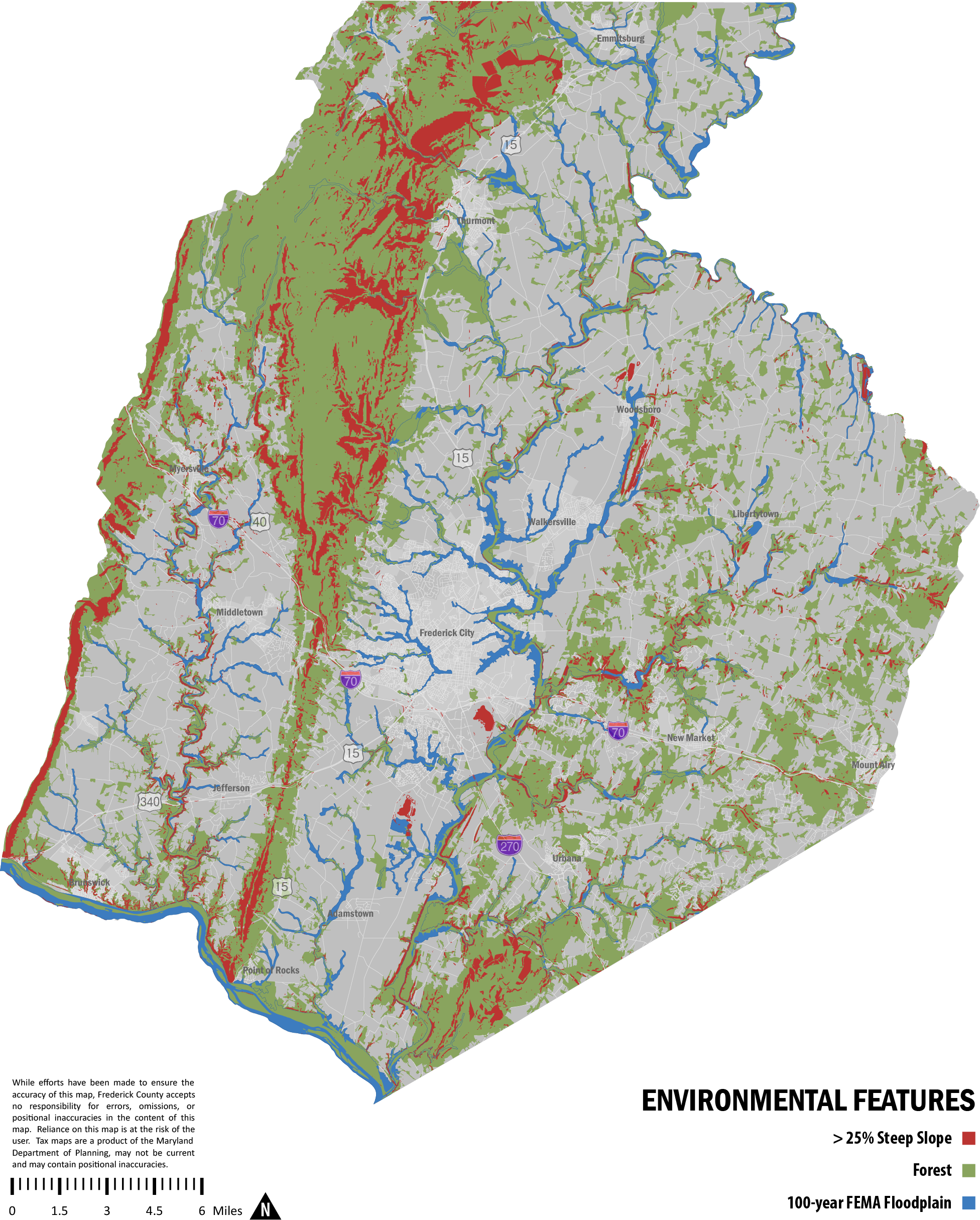
100 Year Floodplain
The 100-year floodplain is the portion of the landscape adjacent to streams and rivers that is subject to inundation by a flood event having a 1% chance of occurring in any year. Floodplains are generally comprised of rich alluvial soils formed by many years of deposition of soil, gravel, sand, rock, leaves, twigs, animal and other plant materials caused by the continual ebb and flow of water in and out of the stream or river channel.
Floodplains are a natural part of the aquatic environment and can contain diverse ecosystems. A key function of floodplains is to hold excess water and allow a slow release into groundwater and back to the waterway. Streams and rivers carry higher suspended sediment during flood events; the floodplain acts as a ‘sink’, trapping and settling these particles. The soil microbial community is active in floodplains, processing and cycling nutrients. Unique plants that can tolerate episodic high water are present in floodplains along with a variety of animal species that contribute to high biodiversity.
Habitat of Endangered and Threatened Species
Frederick County’s diverse landscape supports high biodiversity, the variety of plant species, animal species and all other organisms found in a particular environment. The protection of habitats that are critical to maintaining biodiversity contributes to the protection of rare, threatened and endangered plant and animal species.
The Maryland Department of Natural Resources – Natural Heritage Program - has identified 26 animal species and 74 plant species in Frederick County in their current inventory of Rare, Threatened, and Endangered Species. Of these, nine animal species and thirty-five plant species have been determined to be endangered statewide. Two of these endangered species, the Yellow Lance (a freshwater mussel), Elliptio lanceolata and Torrey’s Mountain-Mint, Pycnanthemum torrei, are cited as globally rare. Seven plant species are identified by the state as extirpated. The species “was once a viable component of the flora or fauna of the State of Maryland, but for which no naturally occurring populations are known to exist in the state.” The Maryland Department of Natural Resources’ Fisheries Division also maintains an official list of game and commercial fish species that are designated as threatened or endangered in Maryland.
These rare species serve as bellwethers for the health of the ecosystem that we rely on and share with them. Many of these species serve us directly. They may have medicinal applications or utility for research and education, or cultural significance. The challenge in Frederick County and all of Maryland is how to balance population growth and land development with our responsibility to protect Frederick County’s array of unique habitats and species.
The primary state law that governs endangered species is the Nongame and Endangered Species Conservation Act (NESCA), which contains the official State Threatened and Endangered Species list. The NESCA reads:
"It is the policy of the State to conserve species of wildlife for human enjoyment, for scientific purposes, and to insure their perpetuation as viable components of their ecosystems. Species of wildlife and plants normally occurring within the State which may be found to be threatened or endangered within the State should be accorded the protection necessary to maintain and enhance their numbers."
The Natural Heritage Program (NHP) is the lead state agency responsible for the identification, ranking, protection and management of nongame, rare and endangered species and their habitats in Maryland. Data collected by NHP provide the scientific foundation for the Threatened and Endangered Species lists mandated by the Act. NHP researchers conduct inventory and monitoring activities on nongame wildlife, rare species populations and natural communities, documenting trends in population and habitat health and viability. Information gathered through this research guides land management decisions and regulations designed to protect and conserve the state’s biological diversity.
No exact locations are provided for any of the listed rare, threatened and endangered species (as a means of protecting the listed species), although GIS data depicting generalized habitat/species locations has been provided to the county by the Maryland Department of Natural Resources for land use planning and development review purposes.
Steep Slopes
Steep slopes are defined as having an incline of 25% or greater. Protecting the natural terrain and vegetative features present on steep slopes prevents flooding, stream siltation, and the alteration of natural drainage patterns. Preserving steep slopes protects the natural environment, man-made structures, and the safety of all citizens. Steep slope protection also provides aesthetically attractive open space/view sheds and maintains local biodiversity found on many of these slopes. Preservation of steep slopes adjacent to watercourses is especially important because of the impact to water quality and in-stream aquatic habitat from soil erosion and sedimentation when slopes are graded, cleared or disturbed. Historically, many of these steeply sloped areas have not been disturbed, as they are very difficult to farm, graze, log or develop.
Frederick County’s distinct landform regions, called Physiographic Provinces, can be used to describe the county’s overall topography. The Blue Ridge Physiographic Province includes Catoctin Mountain at the eastern boundary and South Mountain at the western boundary. These mountain ranges contain the largest concentration of steep and moderate slopes in the county.
The Piedmont Plateau Province includes all lands in Frederick County east of the Catoctin Mountain range and is typified by rolling terrain and low ridges. Steep and moderate slopes exist along many streams in the Piedmont in Frederick County. Steep slopes are evident along Bush Creek, Linganore Creek and its tributaries south of MD 26. Numerous steep ridges and bluffs are also present adjacent to the Monocacy River as well as Catoctin Creek. In addition to the mountain ranges, Frederick County has a Monadnock (a mountain or rocky mass that has resisted erosion and stands isolated in a plain): Sugarloaf Mountain. It rises 800 feet above the Piedmont Plateau Province to an elevation of 1,282 feet.
Forest Lands
Forests provide countless benefits including: air quality, water quality, health, scenic beauty, wood products, wildlife habitat, recreation, flood control and erosion control. According to the Maryland Department of Natural Resources Forest Service, the predominant forest cover type in Frederick County is the Oak-Hickory complex (oaks, hickories, red maple, beech, tulip poplar, white ash). Other forest cover types found in the county include the Northern Floodplain: elm, black walnut, ash, sycamore, willow; Northern Hardwood: sugar maple, beech, hemlock, basswoods, white ash, red oak; and others such as pine plantations and early succession forests.
Presently, the major forested areas of the county lie in the mountain areas, including Catoctin Mountain, South Mountain and Sugarloaf Mountain and its immediate vicinity. The forest cover in the eastern county area, however, is much more fragmented, interspersed with large agricultural fields or residential development. Some forestland is also present in the Monocacy River and Potomac River riparian areas. Some forestland in the county is publicly owned and the remainder is privately held with the potential for some commercial timbering and harvesting.
Monocacy Scenic River
The Monocacy River is Maryland's largest tributary of the Potomac River. The River’s headwaters are formed by the confluence of Marsh and Rock Creeks in Pennsylvania and flow 58 miles to the Potomac River. The Monocacy River bisects the county as it flows south of Miller’s Bridge (MD 77) at Rocky Ridge. North of MD 77 the river divides Carroll County from Frederick County. The Monocacy drops just 170 feet along its course, giving it an unusually gentle gradient for a Piedmont River.
The Monocacy is a unique and vital resource in the county, used for public water supply (City of Frederick, Ft. Detrick), effluent disposal, recreational pursuits and scenic enjoyment. The Maryland DNR has identified several areas in the Monocacy River corridor that contain habitats of rare, threatened, or endangered species. The river’s riparian area also contains numerous Wetlands of Special State Concern. These wetlands have exceptional ecological value and often contain the last remaining populations of native plants and animals.
The Maryland Department of Planning included the Monocacy in its 1970 study, Scenic Rivers in Maryland, and identified the Monocacy as a significant State resource, worthy of immediate study, and a prime candidate for State Scenic River designation. The Monocacy River was designated and added to the Maryland Scenic and Wild River System in 1974. A Monocacy Scenic River Local Advisory Board was formed in 1976, comprised of citizens from both Carroll and Frederick Counties, and appointed by the respective Boards of County Commissioners. The role of the river Board is to provide advice and recommendations to the Frederick and Carroll County Governments on land use, land development proposals and resource management issues that impact the Monocacy River and to serve as advocates for the river and its varied resources.
The River Board in conjunction with the Maryland Department of Natural Resources prepared The Monocacy Scenic River Study and Management Plan in 1990. Both Carroll and Frederick Counties jointly adopted the Plan in May 1990.
Limestone and Karst Areas
Limestone is a very common sedimentary rock. It is composed mostly of the mineral calcite and can have varying amounts of clay, silt, and sand as layers within the rock. Metamorphosed, fairly pure limestone forms marble. High calcium limestone and its metamorphic equivalent, marble, are used in the manufacture of Portland cement, agricultural lime (a soil amendment), and in addition to their use as crushed stone used as aggregate. A carbonate rock, limestone is subject to erosion by groundwater and the formation of solution channels and sinkholes. While these channels are capable of carrying substantial quantities of groundwater that can be tapped for water supply purposes, they can also serve as conduits for groundwater contaminants.
A belt of limestone conglomerate runs north from the confluence of the Monocacy and Potomac Rivers, through City of Frederick to the Town of Woodsboro. This area, known as the Frederick Valley, is underlain by two main limestone formations—the Frederick Limestone and the Grove Limestone. The Frederick Limestone formation is a dark, impure limestone characterized by thin layers with many shaly interbeds, which tend to make the formation unfit for crushed stone. Grove Limestone is quarried at several locations in the Frederick Valley: two operations near Woodsboro, one at Lime Kiln near Buckeystown, and one just southeast of Frederick City.
Sinkholes
Karst topography may be prone to the formation of sinkholes, which is a gradual and sometimes sudden collapse of the topsoil into a void. Sinkholes may be triggered by human activity such as excessive pumping of groundwater, which creates voids in the limestone rock and the discharge of storm water from roads or development that erode the limestone. Most sinkholes that form suddenly occur where soil that overlies bedrock collapses into a pre-existing void. Their presence indicates that additional sinkholes may develop in the future.
Environmental concerns include the introduction of contaminants and pollutants into the groundwater; catastrophic collapse and gradual subsidence of the lands surface; and flooding during or following intense storms. In fact, stresses induced by human activity in areas of karst topography result in environmental problems that are much more acute than those that would occur in terrains underlain by other types of rock. However, urbanization is increasingly affecting many areas that have karst topography, resulting in several karst-related environmental problems. Karst topography, particularly that of moderate to high sinkhole density, imposes constraints on land use. Mismanagement of areas of karst topography through unsound development, poor farming practices, improper waste disposal or other means, can damage ground water resources, subterranean ecosystems of cave networks, or man-made structures.
Changes to surface drainage may alter the rate at which the underlying karst aquifer receives it normal recharge (groundwater inputs). Vegetation slows runoff from storms and allows water to percolate into the soil. However, runoff from impermeable surfaces (cement drains, roads, parking lots, rooftops) may rapidly be funneled through sinkholes into the aquifer. Artificially filled sinkholes may become blocked inputs. Increasing the rate of runoff and/or blocking input points may cause surficial water to pond or flood, unless it’s diverted away from its natural sink point (thereby altering the recharge at yet another sink point). This may drastically affect the amount of groundwater available for use in the immediate vicinity.
Groundwater Quality
The most important current and future environmental issue with respect to areas with karst topography is the sensitivity of karstic aquifers to groundwater contamination. The effect of human activity on areas of karst topography is most severe in cases where polluted surface waters enter karst aquifers. There is a general lack of public understanding of groundwater behavior, particularly in areas with karst topography. Karstic aquifers cannot filter contaminated groundwater sufficiently to render it potable at the discharge sites (e.g., springs emerging on the landscape). Water travels rapidly through solution conduits because recharge points (groundwater input areas) are directly connected to discharge points. Sinkholes are natural funnels that convey toxic substances directly into the karstic aquifers.
Wetlands
Wetlands are a unique type of ecosystem and are also referred to as marshes, swamps and bogs. They are generally identified based on the degree of flooding, the existence of unique plant communities, and by special soil characteristics. Wetlands may be permanently flooded by shallow water, permanently saturated by groundwater, or periodically inundated for periods during the wet season.
Frederick County has inland wetlands, as opposed to coastal or tidal wetlands. Inland wetlands are most common within floodplains along rivers and streams (riparian wetlands), in isolated depressions surrounded by dry land, along the margins of lakes and ponds, and in other low lying areas where the groundwater depth is shallow. The benefits of wetlands are described below:
Plant and Animal Habitat – Many species of birds, mammals, reptiles, and amphibians rely on wetlands for breeding, food supply, cover, wintering and stopover during migration. They create numerous microenvironments for wildlife. Wetlands also provide unique habitat for many rare and endangered plants and animals.
Water Quality – Wetlands play a less conspicuous but essential role in maintaining high environmental quality, especially in aquatic habitats. They do this in a number of ways, including purifying natural waters by removing nutrients, chemical and organic pollutants, and sediments, and by producing food that supports aquatic life.
Flood Control – The more tangible benefits of wetlands include flood and storm water protection, erosion control, and water supply and groundwater recharge, harvest of natural products, livestock grazing and recreation.
Protection Measures
As of the adoption of the LFMP, the following protection measures are used by the county to address the protection of natural resources and the sensitive areas.
Waterbody Buffer Ordinance: A countywide waterbody buffer ordinance (contained within the Zoning Ordinance) was adopted in 2008 that applies to all perennial and intermittent streams in the county, excluding the municipalities. The ordinance is applied at the subdivision review stage and regulates construction and grading activities on new residential, commercial and industrial subdivision lots.
Floodplain Regulations: The county’s Zoning Ordinance regulates development in the 100-year floodplain, historic floodplain, and flooding soils. These regulations apply to all of the county’s zoning districts and are implemented through the development review process and the review of building permits for existing lots. The regulations prohibit grading and the construction of buildings or impervious surfaces within FEMA floodplains and within a specified distance measured from the floodplain boundary.
Zoning Ordinance: The identification of steep slopes on all site development plans and subdivision plats is required by the zoning ordinance and subdivision regulations. Septic systems are prohibited within steep slopes due to the surfacing of effluent regardless of soil type or depth of leachate trenches.
Wetlands and flooding soils (soils with characteristics of temporary inundation) are regulated in the Floodplain District section of the Zoning Ordinance. Development, impervious surfaces, grading, or in-filling is not permitted in wetlands or the FEMA 100-year floodplain. A specified setback is required from all wetlands. Both the Maryland Department of the Environment and the US Army Corps of Engineers are involved in designating wetlands.
Wellhead Protection Ordinance: In 2007 the county adopted wellhead protection legislation that regulate hazardous substance storage tanks. Any tank within certain distances of community groundwater supply wells must be above ground with 100% catchment basins or double-walled containment and spill protection alarms. The wellhead protection regulations also prohibit certain land uses and activities within wellhead protection areas.
Forest Resource Ordinance: The county’s Forest Resource Ordinance (FRO) was adopted in 1992 and is applied through the development review process to subdivisions and site plans. The FRO allows for on-site or off-site afforestation, purchase of forest banking credits, or a fee-in-lieu payment into the forest fund. The highest priority for meeting FRO requirements is the afforestation of stream valleys within the particular development or at least within the same watershed. Further, FRO afforestation and forest ‘banking’ priority areas are stream valleys on agriculturally-zoned land.
Resource Conservation Zoning: The Resource Conservation (RC) Zoning District is applied throughout the county, with the largest portion comprised of the forestlands on and around Catoctin Mountain, South Mountain and Sugarloaf Mountain. The RC Zone limits new residential subdivision lots to 10 acres in size and prohibits development on slopes of 25% or more. The RC zone does not permit the construction of new public streets as part of residential subdivisions. Timber harvesting is permitted in all zoning districts with an approved logging permit. The Frederick County Forestry Board must also review and approve proposals for timber harvesting in the Resource Conservation zone to ensure sound forestry best management practices are employed.
Development Review Process: The Maryland Department of Natural Resources has an opportunity to review proposed subdivision and site plan applications to determine the existence of threatened and rare species on a subject site.
Stream Restoration: The National Pollutant Discharge Elimination System Program (also known as the county’s stormwater permit) requires water monitoring, watershed assessment, public education, and the restoration of degraded stream corridors. The county’s first restoration project was completed in 2007 and involved stream channel rehabilitation and riparian buffer plantings along a portion of Ballenger Creek at the Ballenger Creek Elementary School.
Natural Resource Comprehensive Plan Designation: The Natural Resource land use plan designation is applied in the county to mountain areas with contiguous forests and to stream corridors. Stream corridors include major streams defining the county’s 20 subwatersheds. Also included within mountain/forestlands and stream corridors are 100-year floodplain, plant/animal habitats, steep slopes, and wetlands. A purpose of the land use plan designation is to identify and highlight these features relative to growth areas. The plan designation itself is not a regulation, but it does provide the basis for considering the application of Resource Conservation zoning.
Public Ownership: Public ownership of parks and natural resource protection areas provides the greatest degree of protection for any sensitive area feature. There are over 25,000 acres of predominantly forested land under municipal, state, and federal ownership. Municipal ownership is comprised of watershed protection lands primarily in the Catoctin Mountains. State lands include Catoctin and South Mountains. While forestland is the predominant feature under public ownership, also included within these areas are steep slopes, streams, habitat of threatened and endangered species, and wetlands.
Sugarloaf Mountain Rural Heritage Landscape
The area surrounding, and including, Sugarloaf Mountain – located along Frederick County’s southern edge in the largely undeveloped wedge of land between the Interstate 270 corridor and the CSX Rail line (Frederick spur) – continues to maintain its locally iconic status. This valued rural preserve, punctuated by the visual prominence of the mountain’s dual peaks, and grounded by the beauty and history in the surrounding fields and forests, is recognized as a special place even in a county that is home to many special places.
The Sugarloaf area has already been demarcated as the Sugarloaf Mountain Historic Survey District which covers approximately 10,500 acres of land including the 3,200 acres which make up the mountain itself and have been preserved by Gordon Strong and his heirs under the Stronghold Trust. Immediately west of the Sugarloaf district is the Carrollton Manor Rural Historic District (9,300 acres), the Washington Run Rural Area (2,715 acres) and, across the Potomac River in Loudoun County, Virginia, the Catoctin Rural Historic District, a 25,000-acre National Register District. In addition, Montgomery County’s Agricultural Reserve district – with its tens of thousands of acres of permanently protected farmland is located along the Frederick-Montgomery County line, immediately adjacent to the Sugarloaf area.
Several long-term protective easements have also been established in and around the Sugarloaf area including those held by the Maryland Environmental Trust, the Maryland Department of Natural Resources, the Maryland Agricultural Land Preservation Foundation, the U.S. Government, and Frederick County, through its Installment Purchase Program (IPP).
As a cherished Frederick County locale, the Sugarloaf Mountain area highlights the natural, historical, and cultural features that are closely associated with the rural pace, majestic beauty, and quality of life that is one of the centerpieces of Our Vision. However, the area remains vulnerable on several fronts:
Land Protection: Much of the acreage in and around the mountain is not protected by long-term easements. While the underlying zoning laws provide some protection from intense residential construction, equally disruptive possibilities exist to forever alter the area through insensitive, large-lot development, fragmentation of agricultural or environmental resources, or operations and uses available to landowners under the current regulatory regime.
Environmental Disruption: Some land uses available to property owners may still allow for impacts that fragment and degrade natural resources and that could greatly diminish the quality of the natural environment. Environmental degradation can include noise pollution, rural road overload, and development.
Viewshed Degradation: Even low-density, low-intensity development could result in the degradation or destruction of cherished views and vistas that have been enjoyed by hundreds of thousands of citizens over the decades.
One approach to the challenge of maintaining the Sugarloaf Mountain region as a truly special place in Frederick County for ourselves and for future generations may involve the establishment of an overlay district. Such a district – established in the Zoning Ordinance – would be drawn and constructed based on environmental stewardship and the Sugarloaf area residents’ vision for this area. This might include: Restrictions on building size or height; Standards or guidelines for building location so as to minimize visibility from prominent locations on or around the mountain; Standards for environmental quality related to livability such as noise, vibration, traffic impacts, or forest removal; Standards for new development to allow for a more traditional pattern based on small crossroads villages and hamlets; Prohibition of certain land uses otherwise available in the Agricultural, Residential, Village Center, and Resource Conservation zoning districts; and Maintaining and protecting the ecological integrity and functionality of the area.
A thorough analysis of the Sugarloaf Mountain area – beginning with the completion of a visual resources analysis and a natural resources inventory – would set the stage for any discussion regarding the drafting of specific guidelines, policies, or regulations.
The Agricultural Infrastructure Sector
The Agricultural Infrastructure Sector is identified to support continued and innovative agricultural development, such as regenerative farming practices, and direct urban/suburban growth away from agricultural resources (Figure 7). Development of rural and agricultural activity is supported, especially within existing rural hamlets identified on the Thematic Plan Diagram.
Frederick County has one of the strongest agricultural economies in Maryland. This economic strength derives from several key components, each of which remains healthy only because Frederick County citizens demonstrate a strong commitment to maintaining the practice and culture of farming.
The collection of resources, activities, systems, and knowledge necessary to nurture a healthy agricultural economy is called our Agricultural Infrastructure. This Agricultural Infrastructure must be diligently maintained, improved or expanded when necessary to respond to changing market demands or evolving technologies, and physically deployed in such a way as to serve the needs of farmers throughout the active agriculture areas in Frederick County. This sector will be further implemented through the development of a Livable Frederick Agricultural Infrastructure Sector Plan. The main components of this plan are as described below.
Figure 7: The Agricultural Infrastructure Sector
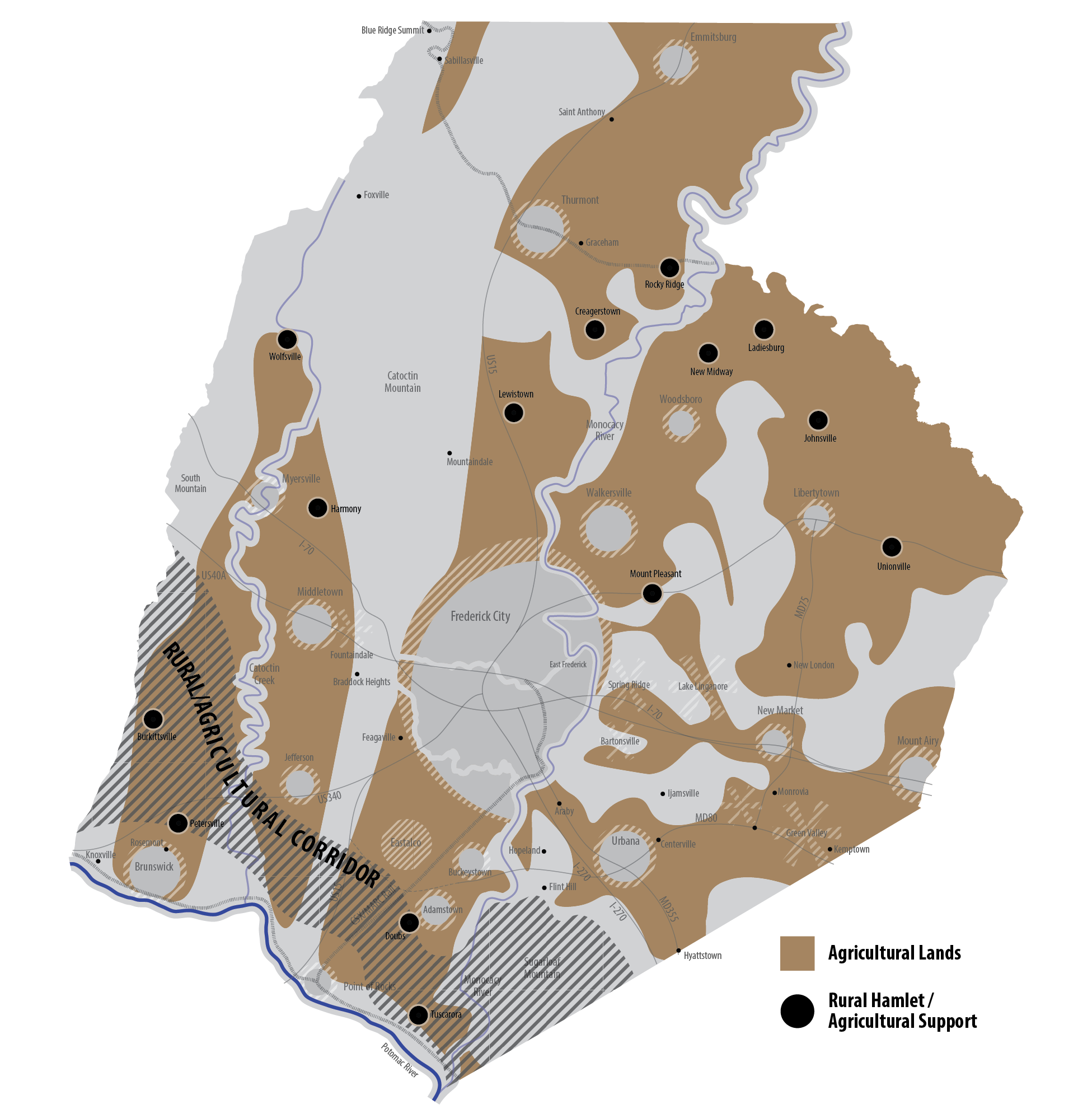
Farmland Preservation
Several programs are at work to permanently preserve farmland in order to maintain a critical mass of agricultural acreage for our farm economy. State, county, private non-profit, and at times, federal programs have thus far contributed to the preservation of over 60,000 acres of farmland in Frederick County.
Rural Reserve
The purpose of the Rural Reserve is to identify and promote the rural agricultural characteristics of the county and potential for agricultural- and resource-based industries. The county's Rural Reserve is designated for those areas outside of the community growth boundaries and encompasses lands in the county designated as Agricultural/Rural. Resource protection tools such as Agricultural Preservation easements, restrictive agricultural zoning, and agricultural economic development are some of the methods used to protect this resource. The Rural Reserve is not to be considered as residual land left over after the delineation of our growth areas, but as specifically identified land areas set aside for the purpose of maintaining the rural character of the county valued by so many of its citizens. The Rural Reserve is intended to remain predominately intact for the future with only minor boundary revisions anticipated in future comprehensive planning efforts.
Priority Preservation
Priority Preservation Areas (PPA) are mapped geographic areas where the county targets and prioritizes its farmland preservation easement purchases and other incentives in order to create large contiguous blocks of preserved farmland and to maintain a critical mass of farm acres to support viable agriculture. With nearly 100,000 acres currently identified in five PPA's, the county will also ensure that its other planning activities do not infringe on lands that provide the foundation for current and future farmers.
MD Code Ann. § 5-408 requires that counties seeking state certification of their agricultural land preservation program include a Priority Preservation Element in their comprehensive plan. The primary component of the Priority Preservation Element is the delineation of PPA’s, which provide a focus for establishing agricultural preservation easements.
According to MD Code Ann. § 2-518, a Priority Preservation Area (PPA) shall: contain productive agricultural or forest soils, or be capable of supporting profitable agricultural and forestry enterprises where productive soils are lacking; be governed by local policies that stabilize the agricultural and forestland base so that development does not convert or compromise agricultural or forest resources; and, be large enough to support the kind of agricultural operations that the county seeks to preserve, as represented in the comprehensive plan.
PPA's are established within the Rural Reserve to target and prioritize land preservation easement purchases and other incentives to preserve land. Further, the purpose of the PPA's is to target land preservation efforts and build critical masses of protected lands on the highest priority properties. In addition the Priority Preservation legislation builds on earlier State efforts through the Rural Legacy Program to concentrate land preservation efforts in those areas deemed to be most important by the county. As such, most of the acreage within the two approved Rural Legacy areas; the Mid-Maryland Rural Legacy Area and the Carrollton Manor Rural Legacy Area has been included within Priority Preservation Areas.
The criteria for establishing Priority Preservation Areas include: land containing prime farmland soils as identified in the USDA Soil Survey for Frederick County; land with existing clusters of agricultural preservation easements; land with the predominance of large farm parcels (100 acres or more); and, land containing high value agricultural enterprises such as dairy farms, wineries, and greenhouse/nursery operations.
Frederick County has a large agricultural land area - over 250,000 acres - with many high-value areas, most of which could be considered for priority preservation. However, in order to truly prioritize preservation efforts and to create an achievable preservation plan, the Priority Preservation Areas are reasonably constrained. The methodology for identifying the PPA's involved the mapping of characteristics including size of parcels, prime farmland soils, existing preservation easements, zoning, comprehensive plan growth boundaries, and high value agricultural enterprises. In total there are 99,038 acres – nearly 40% of the county’s farmland - included in the five Priority Preservation Areas described below.
Mid-Maryland Priority Preservation Area
This PPA predominately consists of the Mid-Maryland Rural Legacy area and encompasses approximately 17,500 acres west of Catoctin Creek, east of South Mountain, extending north of US 340 to Myersville. This is an area of significant prime farmland including two of the three best farmland soils in the county with Myersville and Fauquier loams. This PPA contains the largest contiguous block of preserved farmland in the county, with 8,983 acres (51% of the total PPA and 60% of Undeveloped Land in PPA) under easement.
Carrollton Manor Priority Preservation Area
This PPA contains approximately 18,000 acres located south of Ballenger Creek, east of US 15, west of the Monocacy River extending south to the Potomac River. The MD 85/New Design Road corridor contains the largest concentration of preserved farmland in this PPA and is characterized by larger farms on relatively flat terrain, with some of the most productive agricultural soils (Duffield) in the county. There are 4,213 acres (23 % of the total PPA) under easement and 26% of the undeveloped land remaining within this Priority Preservation Area.
Walkersville Priority Preservation Area
This PPA encompasses approximately 11,000 acres virtually surrounding the Town of Walkersville and extending north to the Town of Woodsboro. The PPA also extends west of US 15 including the Crum and Thatcher properties, which were annexed into the City of Frederick in 2009. The area includes the highest concentration of prime farmland anywhere in the county and includes 1,955 acres (18% of the total PPA) under easement. This PPA encompasses the Town of Walkersville’s growth area that would accommodate potential annexation into the Town for residential or employment development. Currently there are 980 acres of undeveloped land within the corporate limits of Walkersville, which at a density of 3.5 dwellings per acre could yield approximately 2,335 dwellings. This is important in order to recognize the Town of Walkersville's future expansion needs that can be accommodated within the current municipal boundary. As proposed, this PPA will enable Walkersville to maintain its identity - separate from Frederick City to the southwest, and from the Town of Woodsboro to the north.
Middletown/Jefferson Priority Preservation Area
This PPA encompasses 6,000 acres and is west of Braddock Heights and east of Catoctin Creek extending south from Middletown to Jefferson. This PPA was delineated based on the predominance of prime farmland soils and the high percentage of farm parcels greater than 100 acres in size within the Middletown Valley, outside of the Mid-Maryland Rural Legacy area. There are 1,570 acres (27% of the total PPA) under easement, which is 30% of the undeveloped land remaining within the PPA. There are 27 parcels of land that are larger than 100 acres that encompass over 3,960 acres.
Eastern County Priority Preservation Area
This PPA is the largest, encompassing 45,956 acres east of MD 75, west of the Carroll County line and extending south to the Town of New Market. The northern extent is MD 194 north of Ladiesburg. The area includes approximately 11,000 acres (23% of the total PPA) under easement, which is over 27% of the undeveloped land remaining in the PPA. The predominance of prime farmland and existing preservation activity are visible in this area. With the high degree of preservation in neighboring Carroll County, this PPA results in a large regional land preservation area.
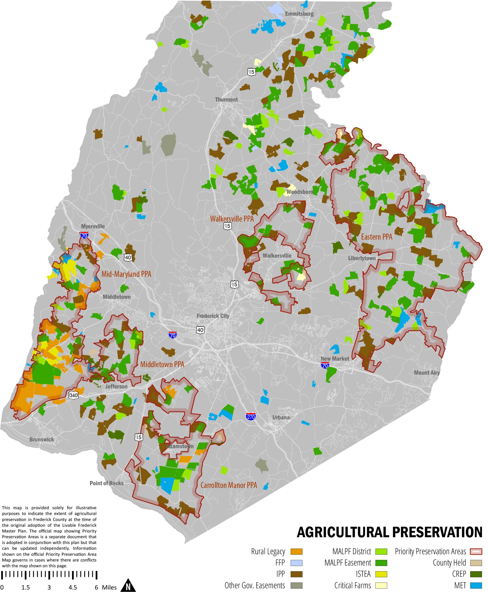
Rural Agricultural Hubs
Our rural hamlets have served historically, and continue to serve, as primary locations for farm support businesses as well as ag-related organizations such as Grange and Ruritan. These small crossroads communities are geographically distributed around the county and many emerged originally to serve local farmers. Importantly, these places provide opportunities for the growth and development of a diverse network of agricultural support businesses while providing the social infrastructure necessary to enhance the lives of farm families. These include farm cooperatives, seed and feed companies, industry trade organizations, agriculture insurers, and food processors, places of worship, and small shops. The county supports the development and maintenance of farm support businesses in our rural hamlets, while committing to provide services to farmers through its economic development and planning departments.
Viable Transportation Options
Transportation facilitates agricultural development, allowing production to be specialized, rural communities to develop, and economies to grow. A safe and efficient network of rural roads and highways provides connections locally and to markets outside of Frederick County. Freight transportation is critically important to the distribution and marketing of agricultural products and goods, as well as for the provision of necessary farm supplies. Freight rail service is provided via two lines: the Maryland Midland RR in the northern end of the county, and CSX which provides rail service in the southern half of the county.
Trucking transportation is readily available throughout the county and offers flexible service. The majority of agricultural products are distributed by trucks on our local roads, as well as our state and interstate highways. Therefore capacity and investment in rural roads, bridges, and other facilities are vital in supporting our farm economy. Trucking’s efficiency, and its linkages to other forms of freight transportation (railroads and port services in Baltimore), enables the county to be competitive in the regional and global marketplace for agricultural products.
Defined Growth Areas
Managing the county’s future growth in a way that is respectful of agricultural resources remains an on-going challenge for citizens and elected leaders. Livable Frederick acknowledges the need to focus most of our growth in existing cities and towns as well as in new compact communities. Our Community Growth Areas also serve as a vital component of local agriculture infrastructure by providing local markets for home-grown farm products.
Agricultural land preservation is an essential component of Frederick County’s plan to ensure that agriculture operations remain economically viable by protecting a critical mass of undeveloped prime agricultural land. Often, when land preservation occurs in proximity to growth areas, this priority aligns with the "Smart Growth" objective of curbing suburban sprawl and re-focusing development into existing downtowns and other areas with appropriate infrastructure. In some cases, the proximity between growth boundaries and permanently protected farmland does not present clear advantages for either growth management or commercial agricultural viability. As such, a rigorous and data-driven assessment of the relationship between growth boundaries and agricultural land preservation that can be applied in case-specific scenarios is warranted.
The Rural/Agricultural Corridor
Located in the southwestern corner of the county, the Rural/Agricultural Corridor designates a broad swath of land stretching from our border with Montgomery County, in the shadow of Sugarloaf Mountain, to the hallowed battlefields of South Mountain, above the Town of Burkittsville. This corridor is a reflection of a swath of agricultural and rural land initially conceived through the Maryland Rural Legacy Program as a key segment of a larger tri-county corridor connecting Montgomery County’s Agricultural Reserve with the farmlands surrounding Washington County’s Antietam Battlefield. This vision of the Rural Legacy Program was partially implemented in Frederick County through the designation of the Mid-Maryland Rural Legacy Area and the Carrollton Manor Rural Legacy Area.
The Rural/Agricultural Corridor identified in the LFMP is a conceptual extension of the Rural Legacy corridor, and is not connected to a specific program or funding mechanism. It is intended to signify a broad corridor of important rural/agricultural land that should be carefully addressed through the development of future land use. This area includes the Sugarloaf Mountain Historic Survey District, the Carrollton Manor Rural Historic District, the Washington Run Rural Area, three Priority Preservation Areas (Mid-Maryland, Middletown Valley/Jefferson, and Carrollton Manor), and thousands of acres of permanently protected land at Burkittsville/South Mountain. This agriculturally productive, culturally rich, and visually attractive area of the county is identified as a key component of our Agricultural Infrastructure due to its broad regional value and its thorough representation of local farming practices and resources. Future growth and redevelopment within this corridor is limited primarily to those community growth areas identified along the transit corridors, and in existing and planned Community Growth Areas.
Rural Roads Program
The Frederick County Rural Roads program was established in 2002. The purpose of the Rural Roads Program is to help protect the scenic and historical qualities of the roads and the adjacent landscape; support, preserve, and enhance the agricultural and rural character of the county; and contribute to a comprehensive, county-wide inventory of rural and scenic qualities. There are roughly 60 roads in the Rural Roads Program, including 45 miles of gravel sections which highlight the rural character of Frederick County history.
Other Development Framework Elements
Development Staging
The purpose of the development staging strategy described herein is to link the timing of development with the provision of adequate infrastructure and community facilities through comprehensive planning, especially in the form of future community and corridor plans. These staging concepts apply primarily to unincorporated growth areas where the county controls zoning, the development review process, and the provision of public water and sewer services. Within municipal growth areas, the primary staging tool is the annexation process itself, which is under municipal control.
Staging principles described below establish broad policies for managing the timing of growth and development. Priority Growth Tier designations will link policy to specific staging mechanisms through community and corridor planning. These staging mechanisms, described below, include specific tools that are available for possible use.
Staging Principles
The following general staging principles provide a framework within which the county can develop more detailed – and parcel specific – development staging policies as individual community and corridor plans are prepared.
Principle #1 – Coordination of development with public infrastructure at the comprehensive planning stage.
Managing the timing and funding of infrastructure is necessary to support the best and most efficient development of designated growth areas. This shall be done as part of the comprehensive planning process in order to provide a high degree of predictability about when and where this development may occur.
Significant infrastructure needs – including but not limited to, schools, roads, water and sewer service, parks, and public safety facilities – shall be identified in the appropriate long range planning documents.
A critical mass of land for development in community growth areas is required to facilitate the provision of infrastructure improvements. The scale and intensity of development in these areas must be planned such that the costs to develop and maintain the infrastructure can be reasonably borne by the development.
The county will utilize its Capital Improvements Program (CIP) to strategically allocate its resources to support appropriate growth and redevelopment.
Principle #2 – Funding for infrastructure improvements.
Both the county and the land development community are responsible for providing the funding necessary for infrastructure improvements in Community Growth Areas.
Approval of development in Community Growth Areas is conditioned on the ability of land developers to fund a significant portion of the cost of infrastructure improvements and identify funding mechanisms and sources.
Principle #3 – Public water and sewer infrastructure
The county is committed to establishing consistency between the water and sewer system capacities and the overall development capacity of individual community growth areas. These efforts shall also be coordinated with countywide growth and development potential so that public services and facilities can be made sufficient to serve both residents and employers.
Key elements of community infrastructure shall be planned – and constructed – during the build out of community growth areas, with the understanding that current community growth boundaries may, in future generations, expand beyond those currently envisioned.
The county shall incorporate into its infrastructure planning efforts – and preserve during the engineering and construction of such systems and facilities – the opportunity to provide additional water and sewer capacity beyond that necessary to serve current or short-term needs. Additional efforts will continue which increase the efficiency and performance of our wastewater treatment plants, furthering our ability to maintain clean waterways and extend plant capacity by remaining within the limits of our MDE discharge permits.
Principle #4 – Balance residential and employment development
Assuring the provision of infrastructure that provides for predictable and planned development opportunities for both residential and employment uses throughout the life of this plan, and beyond, is critical as the county strives to provide an equitable allocation to both job and housing sectors.
The county’s growth staging policies and tools should respond to varying short and long term demands for residential and employment development and should be used to focus the limited collective resources of the county and the land development community to create high quality, well-balanced, vital neighborhoods and communities.
The Priority Growth Tier System
In considering the many complex and necessary mechanisms by which planners, land owners, developers and elected officials may exercise control over the staging of development, the following Priority Growth Tier (PGT) system is presented as a guidance tool for establishing the preferred order in which development should occur within the county’s Community Growth Areas. The system also serves as a framework for additional, or alternative, development staging policies that may emerge during the life of this planning document. Examples include:
Reference to the Priority Growth Tier could be used when considering an application for a floating zone or overlay zoning designation within an area slated for growth (Planned Unit Development PUD or Mixed Use Development MXD, for example);
Incorporation into future regulations of preferences – or preconditions – regarding a parcel’s Priority Growth Tier designation in order to steer such development into preferred areas or to prevent extensive ‘leap-frog’ development;
The Priority Growth Tier may also be considered as part of revisions to other planning tools – such as the Adequate Public Facilities Ordinance, or innovative zoning tools – in order to create incentives and encourage development or redevelopment in appropriate areas.
The application of a Priority Growth Tier (PGT) system will occur as part of community and corridor plan updates and will result in the mapping of PGT’s to specific properties based on the ability to serve those properties with adequate facilities and services. As a non-regulatory staging mechanism, the PGT concept can be used to identify the specific infrastructure needs necessary for a property to progress to a higher tier, and thereby assume a higher priority in the county’s land development plans.
Priority Growth Tier 1
Character of Growth: Primarily Infill and Redevelopment of vacant or underdeveloped lands and structures
Infrastructure: Existing and adequate (or easily upgraded) infrastructure.
Timeframe: Present to 6 years (consistent w/ CIP)
Application: Properties within current municipal boundaries or within, or immediately adjacent to, previously developed lands in County Growth Area Communities. Includes Priority Redevelopment Areas. Will have existing zoning.
Priority Growth Tier 2
Character of Growth: Undeveloped lands utilizing proposed infrastructure.
Infrastructure: Not presently served or adequate, but planned
Timeframe: Mid-term, 10-25 years
Application: Most likely in planned annexation areas of municipalities and in planned unincorporated County Growth Area Communities
Priority Growth Tier 3
Character of Growth: Maintain current agriculture and/or open space lands. Land Banking for future generations.
Infrastructure: Neither currently served nor planned
Timeframe: Long term, beyond 25-year timeframe of this Plan
Application: Within Growth Area Communities (municipal or unincorporated) but within a Future Growth Area i.e. designated Agricultural/Rural.
Staging Mechanisms
Staging Mechanisms are the primary tools used to ensure that development activity does not outpace the ability to adequately serve it with critical services. These mechanisms can employ either regulatory devices or policy level strategies to determine when development should occur relative to the availability of infrastructure and community facilities. The regulatory means, which act as staging mechanisms to control the timing of planned development, are generally employed once a property is proceeding through the development review process. Policy level strategies, such as the establishment of Community Growth Areas, the application of land use plan designations, or the identification of Priority Growth Tiers, seek to establish staging mechanisms well before the development review process. Below is a summary of staging mechanisms for development.
Community Growth Area
The delineation of Community Growth Areas (CGA’s) is the first step in development staging. Properties falling within a Community Growth Area are expected to develop at some point in the future. The CGA boundary is not meant to delineate an ultimate limit for development but is generally sized to accommodate projected residential, commercial, and employment needs for period of approximately 20 years.
Land Use Plan Designation
The application of land use plan designations may be used within Community Growth Areas to differentiate between properties expected to develop within the time horizon of the Comprehensive Plan versus properties that may be considered for development beyond that time frame. The application of a land use plan designation other than Agricultural/Rural, such as residential, commercial, industrial, or institutional indicates that development is appropriate on those properties within a 20-year timeframe subject to completion of other staging mechanisms.
"Future Growth Areas" are indicated by properties within CGA's, but that are designated Agricultural/Rural. This condition indicates development will occur beyond a 20-year timeframe. This reference identifies appropriate growth needs beyond 20 years in order to provide predictability about where future growth will occur when adequate infrastructure and community facilities are available to serve those properties.
Zoning
The application of specific zoning designations on lands within Community Growth Areas allows the county the greatest degree of control over land development while providing optimal leverage in requiring developer-funded infrastructure improvements. However, this leverage is severely limited - if not eliminated - when Euclidean zoning is applied through a comprehensive zoning process. Floating Zones, such as the Planned Unit Development (PUD) and Mixed Use Development (MXD) zones, are not applied during the course of a comprehensive process and thus offer the greatest opportunity to control the development timing as well as require infrastructure improvements by the land developer. Properties that fall within a CGA and that are assigned a land use plan designation indicating a plan for future growth may, in some cases, remain zoned Agricultural and are considered ‘Future Growth Areas’.
Water and Sewerage Plan
The primary purpose of the county’s Master Water and Sewerage Plan is to provide for public water and sewer service. The classification system employed provides an indication of timing for the extension of public water/sewer service to a particular property. The plan also provides a strategic framework for maximizing the performance of our existing water and sewerage systems by providing information about planned upgrades and improvements to the physical infrastructure. In concert with the Capital Improvements Program and NPDES Watershed Protection and Restoration Program, the Master Water and Sewerage Planning process allows for an on-going analysis of our water and sewerage needs considering system capacity, environmental impacts, and system costs.
Public Facility Financing Plan
The level of infrastructure improvements needed for the development of a Community Growth Area should be identified at the comprehensive planning level. A Development Staging Plan for a community growth area will identify specific infrastructure improvements necessary for development or redevelopment to proceed in that area.
Land developers proposing significant land development projects must prepare financial plans as part of their rezoning applications in order to provide clarity about how and when public facilities and infrastructure will be funded and constructed.
A financial plan includes the following elements:
- Land dedication
- Cash contributions to the county for specific public facilities/infrastructure
- Specific facility/infrastructure improvements to be constructed by the developer
- Proposal for an additional property assessment i.e. a Community Development Assessment (CDA) subject to appropriate county and state authorizations.
- Identification of facility/infrastructure improvements proposed by the county in its CIP.
- Identification of other funding sources and/or projects by the State.
Adequate Public Facilities Ordinance
The Adequate Public Facilities Ordinance (APFO) serves as a staging mechanism at the point that a project reaches the development review process. Ultimately, approval of a planned development, a preliminary subdivision plan, or a site plan is contingent upon having adequate school, road, and water/sewer capacity as defined in the APF ordinance. APFO approval for specific land development proposals generally establish phasing conditions that are linked directly to the provision of adequate infrastructure. This approval is formalized through the execution of a Letter of Understanding between the developer and the county government.
Priority Redevelopment Areas
Alternative APFO standards, or differentiated APFO testing benchmarks, may be considered for properties located within a county-designated Priority Redevelopment Area. This approach can be useful in efforts to create an attractive environment for the infill and redevelopment activity crucial to the revitalization of older neighborhoods and corridors within Community Growth Areas.
Mineral Resources
Frederick County has a long history of mining mineral resources. While the mining of minerals such as iron ore and copper are no longer active, other resources such as limestone have been mined in Frederick County since the early 1900’s and still have 50 or more years of life in current mining operations.
Limestone, Shale, and Crushed Stone
The Grove and Frederick Limestone formations follow the Frederick Valley from just north of the Town of Woodsboro to the Potomac River. High-calcium limestone and its metamorphic equivalent, marble, are used in the manufacture of Portland cement and agricultural lime, in addition to their use as crushed stone.
Shale is used for the production of brick and terra cotta products such as pipe and tile and is found in Frederick County throughout the Triassic Upland areas. A type of shale found along the eastern margin of the Frederick Valley is used in the manufacture of lightweight aggregate. The Gettysburg Shale, found only in the western part of the northern Triassic Upland, is the most promising source of material for brick and tile. At present, this formation is mined near Rocky Ridge for brick manufacture.
Lightweight aggregate is produced from shale, which has the special property of expanding when heated. The resulting material is a light, sponge-like product, which has a high compressive strength, suitable for use as aggregate in structural concrete and concrete block. Lightweight aggregate is currently produced at a plant near Woodsboro.
Several types of rock in Frederick County are suitable for crushed stone, but at present only limestone and marble is being mined for this purpose. These rocks are most desirable because of the relatively low operating costs of extraction and processing as compared with other rock types. The Grove Limestone, which occurs in a strip along the center of the valley, is quarried at an operation located south of Interstate 70 and east of Interstate 270 near Frederick City and at an operation located in Woodsboro. The Wakefield Marble occurs in narrow bands within the phyllites and metavolcanic rocks of the Piedmont Upland area south of Union Bridge in Carroll County.
Planning Measures
Active mining operations have been designated on Frederick County’s comprehensive plans since the adoption of the first land use plan in 1959. The Mineral Mining land use plan designation has been applied to active mining areas and to lands that are targeted for the expansion of mining operations. Any land with an Agricultural/Rural land use plan designation is eligible for an application of Mineral Mining zoning. There have not been any proposals to develop entirely new mining operations since the late 1980’s.
Active mining operations in the county are currently zoned Mineral Mining (MM) with the exception of an operation to the east of Thurmont along Rocky Ridge Road, which is zoned General Industrial (GI). The GI zoning district permits mineral extraction and mineral processing as permitted uses. The MM zoning district also permits mineral processing. Beyond the existing and proposed mining operations the county does not identify future mineral extraction areas.
Deep pit quarries have potential for significant impacts on the ground water if they extend below the water table. De-watering of the pit can cause nearby wells to go dry, and in karst terrain, can induce the formation of sinkholes. State legislation calls for delineation of “zones of de-watering influence” (ZOI) around certain quarries and the quarry operator is required to remedy certain damages within the zone. These zones of de-watering influence have been delineated around four quarries in Frederick County.
Even though most large quarry operations intend to extract materials for many years, eventually, mining will cease and some sort of reclamation must be achieved. Deep pit quarries present unique challenges and opportunities for reclamation. Consideration must be given to the safe re-use of these properties once mining has ceased.
Water Resources
Water Resources are addressed in a separate document as a component of the Livable Frederick Master Plan. This separate document serves as the county‘s Water Resources Element (WRE) as required by Md. LAND USE Code Ann. § 1-410. The WRE will be updated with subsequent updates of the county Comprehensive Plan to reflect demographic, economic, and development conditions. The latest official version of this document is hereby adopted as a component of the Livable Frederick Master Plan.
Water and Sewer
Most Frederick County residents obtain their water from publicly-owned community water systems - water supply systems that serve at least 25 people or have at least 15 service connections for a minimum of 60 days per year. In 2013, 27 different water systems located throughout Frederick County served approximately fifty-nine percent of the population. Seven are regional systems that are owned and operated by the Frederick County Division of Utilities and Solid Waste Management. Nine are owned and operated by municipalities. One system is federally owned and serves Fort Detrick, and another privately owned institutional system serves Mount St. Mary’s University. The remaining five serve individual subdivisions and residential developments. In addition, there are several smaller publicly-owned and privately owned community water systems.
Frederick County has 13 major sewer service areas served by 17 sewer systems. Eight of these sewer systems are owned and operated by municipalities. A system owned and operated by the federal government services Ft. Detrick. Frederick Count owns and operates 10 waste water treatment plants with a total average capacity of 16.43 million gallons per day. In addition, there are six, small, publicly-owned, sub-regional community sewerage systems outside of sewer service areas.