A New Kind of Plan
Livable Frederick
Livability is the sum of the factors that add up to our quality of life in Frederick County. It is the ability to easily get where you're going, to enjoy great parks, to benefit from great schools, to find support when you need it, to form bonds with your neighbors, to have access to excellent stores, restaurants, and entertainment, to have good jobs close to home, to enjoy the revitalizing qualities of our forests, rivers, mountains, and countryside, and to be in harmony with the systems that surround, support, and underlie our ability to live happy, healthy, long, and prosperous lives.
To preserve, sustain, and create livability, we must define and advance our shared values as they impact our built and natural environments, our community health, our economic prosperity, our social stability and equity, our education, and our cultural, entertainment and recreational opportunities. This is the central ambition of Livable Frederick. It is a bold and visionary purpose, but one that is at the heart of every technical and practical effort to plan our communities.
Livable Frederick embraces comprehensive planning that is centered on creating and sustaining livability. The Livable Frederick Master Plan takes this concept from an urgent but somewhat vague notion to a vivid illustration that can serve as the well-spring of our efforts to create and sustain our community in this new century.
The Livable Frederick Master Plan
Livable Frederick, through the creation of the Livable Frederick Master Plan (LFMP), embodies a focus on policy and general growth strategy in order to articulate a clear direction for Frederick County in the face of future change. An important part of many comprehensive plans involves the charting of ideas, concepts, principles, goals, and procedures for setting a course of future action and to establish a normative basis of action by providing benchmarks for determining outcomes that are “good” (desirable) or “bad” (undesirable). This is a central role of the LFMP, which together with the Comprehensive Plan Map, future community, corridor, large area, and functional plans, and other important pieces of comprehensive planning in Frederick County, as a whole constitute Frederick County's Livable Frederick Comprehensive Plan. In addition, the LFMP describes approaches to communicating and structuring comprehensive planning in Frederick County that are unlike past planning efforts.
New Approaches
First and foremost, the LFMP is a policy-focused, as opposed to a capacity-focused, document. It stems from a community-based vision, employed an unprecedented process to involve the participation of numerous community members in the development of the plan, and used a sophisticated scenario planning tool to evaluate possibilities for how we can shape our community in the future. In addition, this plan revives a once common approach to communicating planning strategies by introducing a county-wide growth diagram that draws inspiration from Frederick County's original 1959 Land Use Plan. At the same time, this new plan continues to support the important planning efforts of the past by establishing a foundational part of a living process for planning; a process that is carefully conceived to combine the power of localized planning with the broad sweep and long-term value of a deeply visionary document. See the inset, "New Approaches That Shaped This Plan" (pages 6-7) for a deeper look at these new approaches.
How This Plan Is Organized
The LFMP is organized into three sections:
As illustrated in the following diagram, the springboard for all of the content in this plan is Our Vision. This body of content informed the goals and initiatives articulated in the Action Framework, and shaped the diagrammatic general plan for the county articulated in the Development Framework.
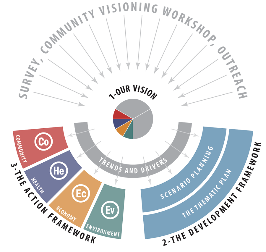
The Three Part Structure of the Livable Frederick Master Plan
Our Vision
The first of three components that comprise the Livable Frederick Master Plan, Our Vision emerged from an extensive process of participation and input from citizens, employers, and leaders in the first half of 2016. Our Vision is a source of understanding about the meaning of livability in our county, and every strategy, goal, and initiative articulated herein emerged from this source.
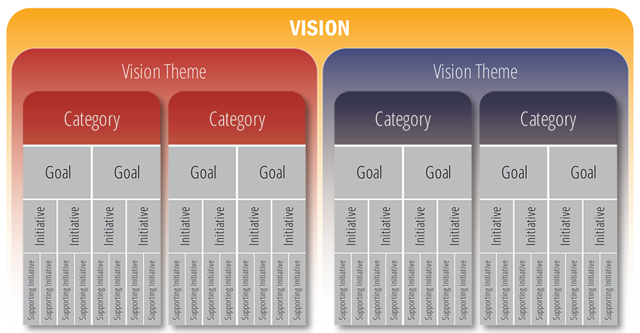
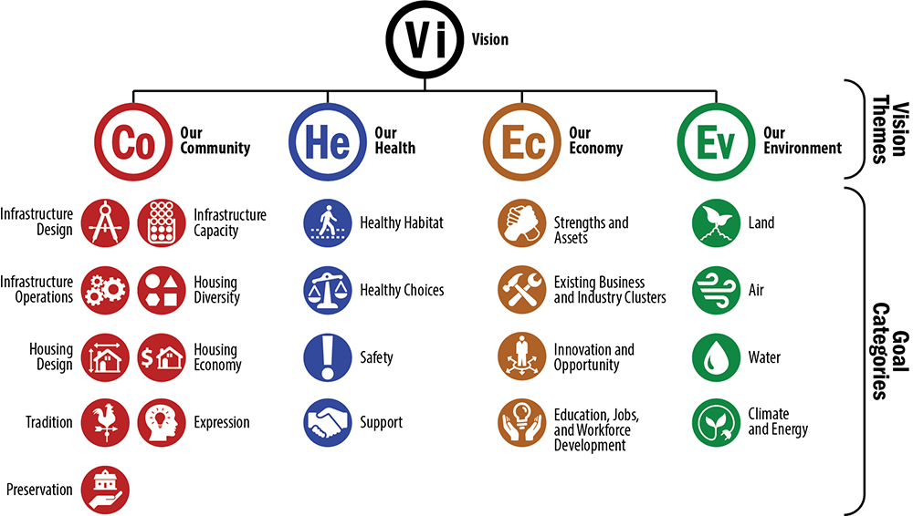
The vision itself is composed of three parts: a statement, a description, and a set of four vision themes. Vision themes were derived from organizing content from the vision into four distinct, function-based groups. They are: Our Community, Our Health, Our Economy, and Our Environment. These four vision themes are described in the Action Framework and serve as the basis for organizing the policy content therein.
Additionally, the vision directly influenced the scenario planning process through the creation of four different countywide development scenarios. The scenario analysis became the basis for the creation of the Thematic Plan described in the Development Framework.
While Our Vision will serve to guide the County government in key areas of long-term and short-term public policy, the content of the Vision statement and description can also serve as a basis for discussion, agreement, and cooperation among other sectors with a stake in Frederick County’s future. The local business community and its representatives, neighborhood and community groups, local and regional non-profit organizations, local institutions (educational, religious, agricultural, etc.), may all borrow freely from the work completed in the Livable Frederick visioning process. Our Vision can be described as ‘open source’ in the sense that we expect, and look forward to, other organizations finding value in its content, and potentially working with the County and others to achieve common goals.
The Development Framework
The Development Framework provides an illustrated analysis and narrative to explain the important ideas and concepts regarding the preferred geographic distribution of future growth. It is composed of two parts: scenario planning and a Thematic Plan (which contains a general plan diagram).
Scenario Planning
This plan utilized growth and development scenarios as a critical tool to evaluate Our Vision. The scenarios provided a systematic means of comparing the likely impacts – both positive and negative – of the planning policies articulated in the LFMP. The alternative growth scenarios modeled for this planning effort consider the relationship between aspects of Frederick County life that are important to supporting livability for our residents and visitors, including the economy, travel patterns, the environment, and the configuration of our neighborhoods. While these scenarios offer different versions of what Frederick County might become in the future, the differences are subtle. Why were the scenarios so similar to each other? The simple answer is that they shared common ‘DNA’, most notably in the form of the following two fundamental assumptions derived from Our Vision:
A Jobs-Based Approach to Future Growth Projections
Assumptions regarding future growth were based upon the jobs and economic activity that Frederick County residents desire. With economic prosperity as a basis for this plan, assumptions about how and where Frederick County will grow in future decades were made clear and became an important building block in all of the scenarios.
Several plausible growth forecasts were considered in the development of the scenarios: Maryland Department of Planning population growth projections, Metropolitan Washington Council of Governments (MWCOG) Cooperative Forecasts, and shift-share growth projections developed by Renaissance Planning. Of these, the growth projections developed by Renaissance Planning provided the basis for the scenario analysis because they provided detail by job and household type that was not available in other projections. Additionally, the Renaissance Planning projections applied shift-share forecasting methods to support the community vision of creating the jobs and economic activity that Frederick County residents want to retain, nurture, and attract.
Multi-Modal Accessibility Focus
Transportation concerns were at the top of many citizens’ lists of things that needed to be fixed in our current and future planning documents. Commuters seek more time to spend with families and to contribute to their communities. Parents demand safe routes for their children walking to and from local schools. Health care professionals implore all of us to become more physically active. Hikers, hunters, and farmers – Frederick County’s original environmental stewards - look for effective ways to protect our air, water, and land resources. The key to addressing all of these issues revolves around providing transportation choices and the land use patterns that support them. Automobiles, trains, buses, bicycles, and our own feet, will continue to serve us well in the future alongside of other modes such as autonomous vehicles. Citizens recognized the need to build a transportation system in Frederick County that supports “multi-modal accessibility,” and this assumption has been ‘baked’ into the scenarios, giving us valuable feedback about the places where we will live, work, and play in the future. The four scenarios modeled are:
Business as Usual: This scenario assumes that we maintain the trajectory of our current planning policies, establishing a future direction that reflects past trends.
City Centers Rise: This scenario acknowledges the City of Frederick, and developed county land surrounding the city, as a major regional center for business, institutions, residential living, and culture. This scenario assumes that the growth potential of areas within and surrounding the city is maximized to create an even stronger urban center boasting walkable neighborhoods, historic character, and thriving commercial districts.
Suburban Place-Making: In this scenario, our suburban communities are recognized as vital places, loved by generations of Frederick County residents. This scenario assumes a pattern of reinvestment in suburban areas of the county in order to create additional opportunities to shop, work, and play closer to home.
Multi-Modal Places and Corridors: This scenario focuses on our physical connections to places beyond and within our borders. Existing rail and highway corridors connect Frederick County to the larger Baltimore-Washington Region and this model assumes a development pattern that makes efficient use of these transportation systems to move people, build new mixed use places, and catalyze the redevelopment of aging retail and office developments. The two primary corridors in this model – the CSX/MARC Frederick Branch and the I-270 Corridor – provide a framework for future development and redevelopment in the southern half of the county.
The scenarios were not intended to function as absolute choices between different options, but rather as a way of finding the best aspects of each to ultimately apply to the Livable Frederick Master Plan. The resulting planning document – including the Thematic Plan – was built using the best attributes of each scenario, and in the end, it can be said that the LFMP is the product of all four growth scenarios.
The Thematic Plan
The preferred pattern and geographic distribution of new development in the county is illustrated in the Livable Frederick Master Plan through a combination of written narrative and diagrammatic mapping. While this plan does not propose to eliminate the use of parcel-based land use mapping - in fact, the Comprehensive Plan Map adopted in 2012 will remain in effect with the adoption of this document - the reliance on parcel-based land use mapping as the sole means of communicating long-range planning goals cannot effectively serve the pursuit of a broader vision. This current effort renews a focus on broad vision and strategy by borrowing from the planning practice of a previous era in which the fundamental ideas for the future shape of Frederick County are presented in a simplified map – an annotated geographical diagram that is a central piece of the Thematic Plan. The following are five important aspects of the Thematic Plan:
- The Thematic Plan represents a vision for the entire county. The form, style, and content of the Plan Diagram share more with the 1959 Frederick County Plan than with the 2012 Comprehensive Plan Map.
- The primary focus of the Thematic Plan is on showing and explaining the geographic aspects of growth related policy preferences. Issues associated with capacity are addressed through the policies presented in the Action Framework. However, capacity-focused planning is intended to occur in separate planning efforts.
- A growth and development strategy for Frederick County is shown in the form of a diagrammatic map – the Plan Diagram. This is not a parcel-based land use map.
- The Thematic Plan keeps the focus on planning strategy, instead of planning tactics. Tactical steps that need to be taken in order to successfully achieve our vision, are addressed as initiatives and supporting initiatives in the Action Framework.
- The thematic, or strategic, approach to charting the future of Frederick County avoids the tendency of citizens, elected officials, and development professionals to immediately skip over policy and begin hammering out a revised land use or zoning map.
The ultimate strategy of the Thematic Plan is to...
…achieve a pattern of development that employs a jobs-based approach to growth and that is centered on multi-modal accessibility in Frederick County, taking advantage of the existing transportation systems in place, the future systems and technologies for moving people and products, and the innovative land use patterns that support transportation choices.
The Thematic Plan incorporates a pattern of growth that leverages the existing “pipeline” of conventional suburban development to satisfy a significant share of the short-term future demand for residences and businesses, while supporting long-term future growth patterns that do not rely primarily on automobiles for access to jobs, shops, and homes. Finally, the Thematic Plan embraces a planning strategy that seeks to enhance growth and development opportunities in and around the City of Frederick, taking full advantage of the infrastructure, institutions, and magnetic appeal of our historic urban center.
The Action Framework
The Action Framework is a collection of goals and initiatives that describe county policy in support of Our Vision. It constitutes the complex and interwoven collection of high-level concepts and policies that feeds into low-level actions. These actions systematically describe a means of moving from the abstractions and general aspirations of the vision to the instrumental and functional details of implementing the vision. This hierarchical approach connects "things we need to do" to their broader purpose, with the ultimate purpose of any of the items in the Action Framework being the realization of Our Vision. Therefore policies articulated in the Action Framework are organized to reflect the four vision themes. Namely, they are:
Our Community: Policies within this vision theme address the underlying physical substrate of our community, composed of the infrastructure, community facilities, housing stock, and cultural and social resources that enable the county to function and prosper.
Our Health: Policies within this vision theme reflect a holistic attitude toward public health that integrates the influence of the physical environment upon individual behavior, as well as the availability of services.
Our Economy: Policies within this vision theme address the inter-relationship between education, economic growth, and social resilience, and focus on strengthening our assets while building our capacity for new and innovative approaches.
Our Environment: Policies within this vision theme address the relationship between our own growth and development, and the vital role of the natural, physical world as a resource and as an essential ingredient to support vital and livable communities.
Beneath each vision theme is policy content composed of goals, initiatives, and supporting initiatives. These were originally developed with the direct involvement of over one hundred Frederick County community member participants, and were informed by the scenario planning process. The goals, initiatives, and supporting initiatives within this plan are organized into categories. Goals articulate a broad purpose within specific categories, initiatives offer more specific direction for achieving each goal, while supporting initiatives provide an even higher level of detail.
The Policy Structure of the Action Framework
Categories of policy are organized by vision theme, drawing a straight line of association between the Action Framework and Our Vision. The result presents a clear hierarchy wherein policies are organized, by their content, into levels that go from the broad (vision) to the specific (supporting initiative) and where lower level items are nested within higher level items that describe intent and purpose.
The Topical Organization of the Action Framework
A key to understanding the Action Framework is that while there is a substantial role for Frederick County Government, it is intended that non-governmental organizations will join with Frederick County and its municipalities in achieving Our Vision. This can occur through partnerships or through parallel benefit resulting from the independent implementation of organizational missions. The Action Framework was developed in partnership with business owners, advocacy groups, and non-profit leaders, and cannot be realized without the continued participation of citizens, developers, business owners, preservationists, farmers, environmentalists, and community organizations.
Goals and Initiatives: A Note Regarding Terminology
Aspirations, policies, goals, objectives, actions, strategies, tactics, initiatives… this kind of language for describing intended outcomes, and the specific means of achieving them, is prevalent in the literature of technical planning documents. The distinctions between their specific meanings can be subtle, and their meanings can vary by situation as well. Therefore, it is prudent to define the terms being used in this document up front.
The Livable Frederick Master Plan is a "policy-based" document. Policy in this case is defined broadly. It is not intended to refer to a prescribed set of behaviors or rules, but rather it encompasses a spectrum of goals, actions, strategies, theories, and approaches that are embodied throughout the LFMP. For example, within the Development Framework, policy is defined through diagrams and text. Within the Action Framework, policy is described in terms of "goals" and "initiatives." Indeed, in its totality, the LFMP is intended to be a clear and direct expression of community planning policy.
As stated above, this plan uses a “goals” and “initiatives” structure to articulate policy in the Action Framework. There are several reasons for this related to the relatively broad scope of comprehensive planning documents as well as the implicit and explicit meanings of the term "initiative."
The scope of this comprehensive planning document is all-inclusive. Therefore, there is limited utility in reducing every issue down to specific objectives or actions. The intent is often to allow subsequent, more narrowly focused plans to be developed for specific issues, projects, or places. These more detailed efforts will provide discrete and definitive measures for implementation. Therefore, a conventional goals/objectives/actions framework - where goals reflect general guidelines, and objectives and actions are specific and measurable - is not employed in this plan.
So, why is this important to our understanding of this plan? Consider that the term "initiatives" is semantically inclusive, providing a more suitable phrase for our purposes. An initiative can include content that could be interpreted as either an objective or action, or in some cases, as a more specific form of a goal statement. In the Livable Frederick Master Plan, the notion of an initiative implies the flexibility needed to allow community institutions, citizens and landowners, and elected officials to make the plan work in the real world. Livable Frederick’s Action Framework is intended to be a community-wide reference for action, not solely a workplan for the county government. "Initiative" implies that implementation can be "initiated" through leadership…from any sector of our community.
Horizon Years
The LFMP is a future-focused document, but what do we mean when we talk about the future? One way to consider the passage of time is to think of the future as the horizon. We know that the Earth extends past the horizon, but our ability to see beyond that line is limited. We use the concept of “horizon years” to consider specific points in time or logical dates for achieving goals. The horizon years referred to in this plan are as follows:
2025: To some the year 2025 represents a time far into the future, but in community planning terms a point in time that is a mere six years away is not so distant. Important data available to the county during this planning process includes 2025 as a reference point. Demographic projections, highway needs, school facility planning, and other critical information looks at our community at the midpoint of the next decade. In terms of our own ‘development pipeline’, 2025 serves as an important gateway between development that has already been approved, and growth that will emerge as a result of the LFMP.
2040: The primary horizon year is 2040. This is the date that the county used in answering some of the big questions presented in the LFMP. Most importantly, Our Vision was developed with this date in mind: Where do we want the County to be in the year 2040?
2050: In the development of growth scenarios, growth and development trends and patterns were modeled through the year 2050 so that we could more readily understand how our proposals would affect the county as it reaches the mid-point of this century.
The Residential Development Pipeline
The residential development pipeline is referenced throughout the LFMP. It is an important concept that is fundamental to a complete understanding of this planning effort. When this plan talks about the residential pipeline, it is referencing the number of houses, apartments, or condominiums that have some type of formal approval from Frederick County through approved subdivision or site plans, planned unit development approvals, or development rights and responsibilities agreements (DRRAs). The total as of January 2019 stands at approximately 33,060 dwellings (countywide approved units) and 21,348 dwellings (available units).
Two measures are provided in order to create a nuanced understanding of the residential pipeline. This is because neither the approved units nor the available units totals are fully accurate reflections of the actual number of housing units that are available for new households in the county. There are several reasons for this, including:
- The approved units total does not account for housing units that have been issued building permits. This means that there are likely to be a significant number of housing units included in the approved units total that are already constructed and occupied and are therefore not available for new households in the county. This results in an approved units total that is an overestimation of actual available units.
- The available units total simply subtracts the number of building permits issued for a development from the total approved units for that development. This does not account for the fact that not all units that have building permits issued are actually constructed and occupied. In fact, there is often a lengthy period of construction and marketing that occurs prior to occupancy. Also, in some cases, when a building permit expires before construction can commence, building permits may be submitted multiple times for a single lot. This means there can be an inflation in the number of building permits that are issued, which artificially reduces the number of units available. Therefore the tally of available units (traditional pipeline) may represent an underestimation of the actual number of available units.
- Some subdivisions are included in the approved units total that may not likely be developed for various reasons. This results in a marginal increase in the number of approved units that could realistically be considered to be available to fulfill housing needs in the county.
The pipeline is not the result of a single elected official, a single moment in time, or a single developer. In fact, it is the sum of all of Frederick County’s planning decisions over the past half-century. The LFMP does not ignore these existing approvals, choosing rather to incorporate those planned developments. As in past years, we know that some of this residential development will not happen due to economic conditions, the changing priorities of land owners, and shifting demand in the housing market. Those development plans that are best suited to achieve the vision set forth in the LFMP will provide a ready supply of building lots for current and future residents of Frederick County.
Maryland's Twelve Planning Visions
The 2009 Maryland Planning Visions law created 12 Visions which reflect the State of Maryland's ongoing aspiration to develop and implement sound growth and development policy. The visions address: quality of life and sustainability; public participation; growth areas; community design; infrastructure; transportation; housing; economic development; environmental protection; resource conservation; stewardship; and implementation approaches. These visions, listed below, are a central and underlying part of the LFMP, which endeavors to implement them through a variety of policies and regulations. The Twelve Visions are:
- Quality of Life and Sustainability: A high quality of life is achieved through universal stewardship of the land, water, and air resulting in sustainable communities and protection of the environment.
- Public Participation: Citizens are active partners in the planning and implementation of community initiatives and are Sensitive to their responsibilities in achieving community goals.
- Growth Areas: Growth is concentrated in existing population and business centers, growth areas adjacent to these centers, or strategically selected new centers.
- Community Design: Compact, mixed–use, walkable design consistent with existing community character and located near available or planned transit options is encouraged to ensure efficient use of land and transportation resources and preservation and enhancement of natural systems, open spaces, recreational areas, and historical, cultural, and archeological resources.
- Infrastructure: Growth areas have the water resources and infrastructure to accommodate population and business expansion in an orderly, efficient, and environmentally sustainable manner;
- Transportation: A well–maintained, multimodal transportation system facilitates the safe, convenient, affordable, and efficient movement of people, goods, and services within and between population and business centers;
- Housing: A range of housing densities, types, and sizes provides residential options for citizens of all ages and incomes;
- Economic Development: Economic development and natural resource–based businesses that promote employment opportunities for all income levels within the capacity of the State’s natural resources, public services, and public facilities are encouraged;
- Environmental Protection: Land and water resources, including the Chesapeake and coastal bays, are carefully managed to restore and maintain healthy air and water, natural systems, and living resources;
- Resource Conservation: Waterways, forests, agricultural areas, open space, natural systems, and scenic areas are conserved;
- Stewardship: Government, business entities, and residents are responsible for the creation of sustainable communities by collaborating to balance efficient growth with resource protection; and
- Implementation: Strategies, policies, programs, and funding for growth and development, resource conservation, infrastructure, and transportation are integrated across the local, regional, state, and interstate levels to achieve these Visions.
Key Insights and Considerations
Based on the ideas presented in Our Vision, input from the Livable Frederick work groups, the scenario analysis, and other studies of existing conditions and future trends, this planning process revealed several key insights that influenced the creation of the Action and Development Frameworks and that will ultimately shape long term implementation strategies, regulatory updates, and future planning:
Pipeline Growth Does Not Sufficiently Reflect The County’s Vision
As of January 2019, the residential development pipeline for both the county and municipalities included 21,348 available dwellings, with 11,789 located in the county jurisdiction and 9,559 located in municipalities. The prevailing development patterns reflected in this pipeline follow a lower density, single-family, suburban residential model. However, if this development reflects conventional models, the new growth will not match the community’s aspirations as articulated in Our Vision, nor will this new development reflect changing trends or market preferences. Pipeline growth could also present challenges to Frederick County as it works to provide needed infrastructure - including schools, roads, and parks - to serve both new and existing neighborhoods. This insight suggests that Frederick County needs new templates for future growth.
Multi-Modal Choices and Active Living: A New Development Model
Developing a new multi-modal transportation network for Frederick County will improve the overall effectiveness of the system and create conditions which promote active living and improve the health of citizens. The reliance on cars as the only transportation option for people to get from point A to point B has created transportation challenges and led to less active lifestyles. We know that we cannot build our way out of congestion, but we can make our system of transportation more efficient by creating a more robust network of roads, transit services, bicycle lanes and pedestrian options. We can also create patterns of development - and grow employment locally - to make it easier for people to get to their jobs, grab a bite to eat, or shop, by taking a short walk, bike ride, transit trip - or even a shorter car ride. This effort could create an opportunity for a large share of our new homes and jobs to be located in areas where there are options available to residents to walk, bike, take transit, or drive shorter distances to reach their daily destinations.
More Housing Choices Necessary to Increase Livability
As housing affordability continues to be a strain for Frederick County citizens, the location and diversity of housing options should also reflect a consideration of creating and maintaining different housing price points – including housing options that remain affordable for as many citizens as possible. Where, and how, people want to live is changing. Different types of households, and people at various stages in their lives, have different needs and desires for the kind of place they want to call home. As the demographics of our community continue to change, so too should our housing options. Housing located in walkable, transit accessible locations can reduce household transportation costs, and reduce the overall housing cost burden on local families.
Reinvesting in Existing Places and Creating Great New Places
The Livable Frederick Master Plan places a premium on the future growth of our towns and villages. Each municipality in Frederick County determines its own amount, rate, and character of future growth – both residential and economic. Frederick County will endeavor to reinvest in its existing suburban communities while finding ways to encourage well-designed, sensitive, residential and employment growth in older villages that are well-suited for, and able to accommodate, appropriate levels of development and redevelopment. Older suburban commercial areas will not be left behind either, as Frederick County works with property owners and neighbors to find new, complementary land uses – including residential uses – for commercial corridors developed in the age of the automobile. Frederick County will work to develop templates for the types of new places that can be oriented around multi-modal accessibility, provide access to jobs, and allow for increased involvement in neighborhood activities.
Promoting Environmental Stewardship and Working Lands Preservation
Environmental stewardship refers to the responsible use and sound management of the natural environment through conservation and sustainable practices. The policies contained in the Livable Frederick Master Plan strive to provide a high quality environment in which to live and work. This includes the protection and conservation of our farmland and sensitive resources including forestlands, mountains, streams, rivers and wetlands. A pattern of growth that focuses the majority of new development in cities, towns, and villages, combined with an enhanced multi-modal transportation network, reduces our development ‘footprint’, and relieves pressure to urbanize our working lands and green infrastructure.
Place-Making as an Economic Development Strategy
A key part of our long term growth strategy is directly tied to creating great places. An increasing number of companies are choosing to locate in places that have ready access to labor talent. Younger workers – particularly those in the creative economy sectors – show strong preferences for living in great places with active main streets and walkable neighborhoods. If we build distinctive and vibrant communities, employers – and those who work for them – will choose to be in Frederick County. As a county that is already blessed with many great communities, it is clear that we have a significant head start in this endeavor.
A Path Forward
Frederick County created its first Comprehensive Plan in 1958. It laid out a vision for growth that balanced the protection of prime agricultural lands, historic places, watersheds, and mountainsides with an accommodation for new jobs and housing, fueled from within Frederick County and from the greater Baltimore-Washington region. This vision put in place a template for growth that reflected the times, lifestyles, environmental conditions, and economic opportunities of its era.
Almost 70 years later, the world has changed dramatically. While many of our core values and quality of life goals have remained, the way in which we work, live, and play has transformed significantly. There is a much greater emphasis today on shaping growth to support more active and healthy lifestyles, sustainable communities, transportation choices, and economic resiliency in the face of rapid technological advances, climatic changes, longer lifespans, and economic restructuring. As such, now is the time to revisit our key policy assumptions about how Frederick County’s tools and incentives for growth might adapt to these changing forces.
Now is the time to embrace a Livable Frederick.
Putting The Plan To Work
The Livable Frederick User’s Guide
A critical portion of any comprehensive planning effort is the set of instructions for how to put the plan to work. Traditionally, planners refer to this as ‘implementation’, but a more appropriate name might be User’s Guide since this describes the best way for users – our citizens, business owners, community leaders, and elected officials – to get the most out of the plan.
This section provides recommendations for administering the planning process as well as creating a solid bridge between the Livable Frederick Master Plan and the many other plans and programs routinely undertaken and adopted by county government, including the Capital Improvement Program (CIP), the Master Transportation Plan, and the Water and Sewer Plan. Additionally, this User’s Guide recommends steps to be taken to monitor, evaluate, and update the plan on a regular basis – over and above any State of Maryland mandate to do so – so that the community may adapt to changing conditions in future years. Most importantly, it provides guidance about who may be best suited to carry out each initiative.
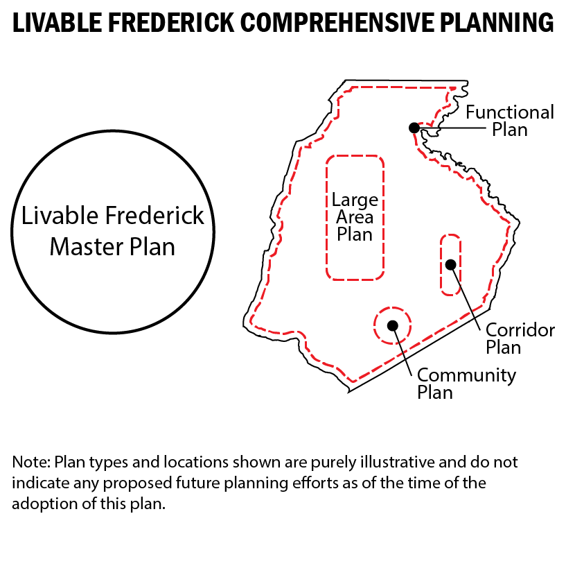
Livable Frederick Comprehensive Planning
The Livable Frederick Master Plan functions as a core document, guiding the continual practice of producing and updating a collection of interrelated planning documents in Frederick County. It provides a framework for future planning that takes into account a deep understanding of the forces shaping our future and our shared aspirations about the kind of place we want Frederick County to be. Future planning in Frederick County will occur under the banner of Livable Frederick Comprehensive Planning.
In many ways, this is a continuation and necessary evolution of past approaches to comprehensive planning in Frederick County. For example, in 1998, a comprehensive plan update occurred that organized the plan into two volumes, a policy document as known as Volume 1, and a set of region plans collectively referred to as Volume 2. Livable Frederick Comprehensive Planning is organized similarly, with the Livable Frederick Master Plan serving as a core, policy-focused document, with a collection of other interrelated plans (such as community and corridor plans, functional plans, and large area plans) that all stem from and support this central core document.
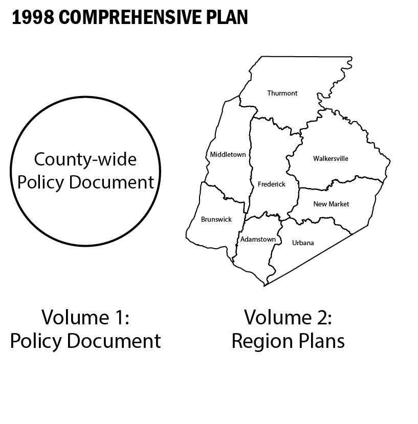
As the diagram below illustrates, in 1998, a comprehensive plan update occurred that created a core policy and technical document entitled "Comprehensive Plan Volume 1." This included the adoption of a county-wide Comprehensive Plan Map. This update marked the beginning of the “Region Plan Update Process,” wherein Frederick County was divided into eight planning regions and updates cycled through each region in sequence.
As each region plan was completed, a new policy and technical document was produced that cumulatively contributed to the overall policy and technical documentation of the Comprehensive Plan. Additionally, new Comprehensive Plan Maps for each region were produced that served to update the overall county-wide Comprehensive Plan Map. This was followed by a rezoning process.
Tap/Click To Enlarge
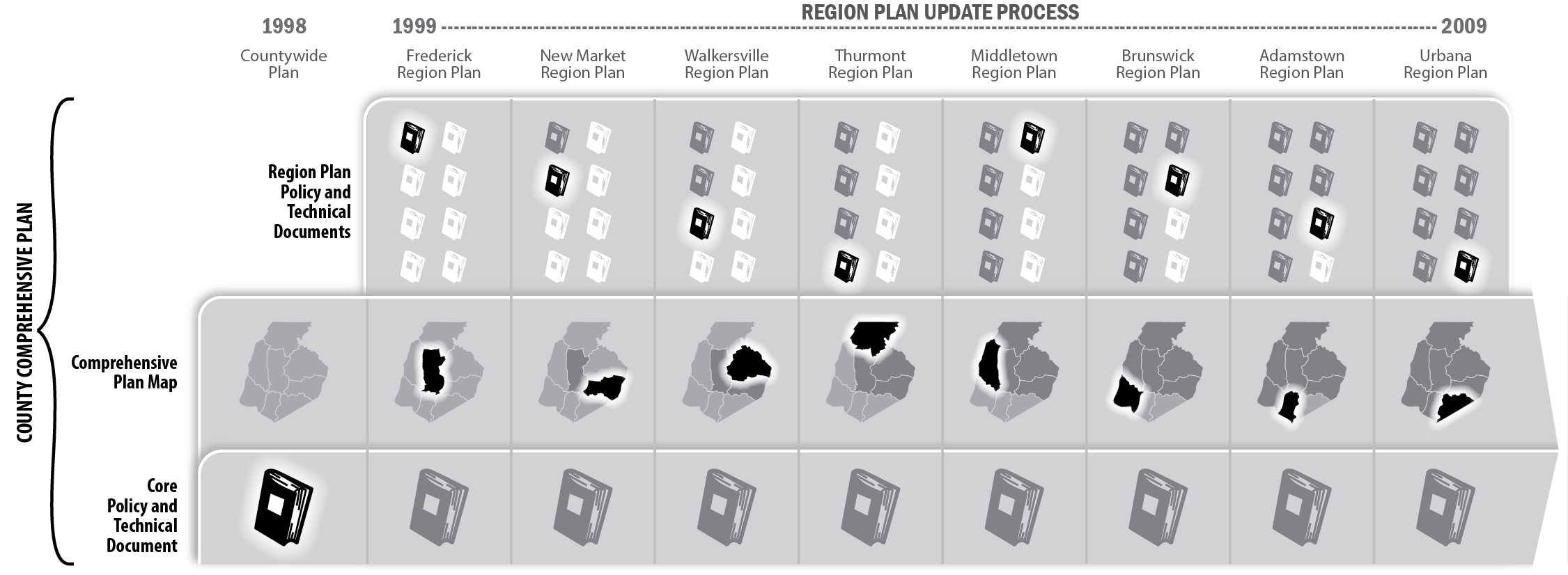
The Region Planning Process was discontinued in 2010 and a new county-wide technical and policy document was created entitled “Frederick County’s Future: Many Places, One Community” (2010 Plan). This included a countywide update to the Comprehensive Plan Map. Importantly, this plan proposed a new model for updating the comprehensive plan that focused on small area planning known as the Communities and Corridors Process. In 2012, another update was undertaken to revise the Comprehensive Plan Land Use Map.
The Livable Frederick Master Plan replaces “Frederick County’s Future” with what represents an evolution of the comprehensive plan’s core policy document. This new vision-based policy plan utilizes a planning diagram - referred to as the Thematic Plan Diagram - to communicate long term growth strategy while employing a scenario planning model to analyze options for our future. The Communities and Corridors Process is expanded in Livable Frederick to include provisions for large area and functional planning.
According to this model, the Livable Frederick Comprehensive Plan is, and will be, composed of the Livable Frederick Master Plan, the Comprehensive Plan Map, future Community and Corridor plans, future "large area" plans, and future functional plans. As Community and Corridor plans, large area plans, and functional plans are adopted, they will constitute amendments to the Livable Frederick Comprehensive Plan.
Tap/Click To Enlarge
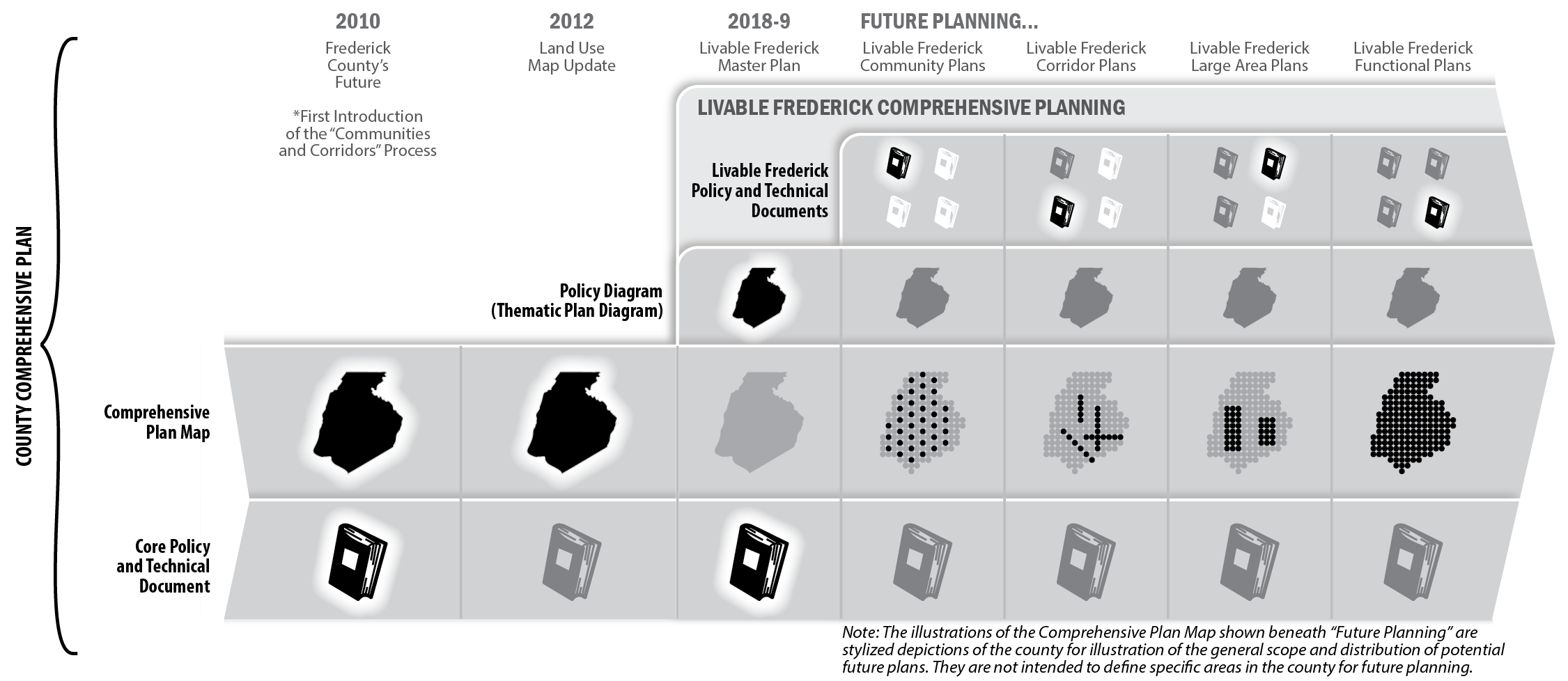
Additionally, other planning elements will be adopted in conjunction with the LFMP. These include the Water Resources element, which originally took the form of a separate chapter in the 2010 Plan. The Growth Tiers Map constitutes another component of the Livable Frederick Comprehensive Plan. A rezoning process typically follows comprehensive plan updates.
Local resources that are important to the history and culture of Frederick County are also addressed in Livable Frederick Comprehensive Planning. One example is the Heart of the Civil War Heritage Area (HCWHA). Frederick County acknowledges full support for the efforts undertaken to assist the HCWHA partners in their efforts to support heritage tourism and thus incorporates, by reference, the Heart of the Civil War Heritage Area Management Plan as most recently updated and approved by the HCWHA Board of Directors.
Components of the Livable Frederick Comprehensive Plan:
The Development Framework Thematic Plan
To be effective, a plan that purports to guide the physical development of a geographical place must include a vivid representation of that place using visual and narrative means. The Thematic Plan component of the Development Framework serves as a visual and narrative guide to the future growth, preservation, and mobility patterns envisioned by citizens of Frederick County and functions as a bridge between the policies laid out in the Action Framework, and the mechanisms through which places are created, such as zoning regulations, land subdivision, large area and community and corridor plans, and the development of physical infrastructure.
The Thematic Plan provides an illustrated indication of where future types of development should occur, where our most valued natural resources and fertile agricultural lands shall remain, and where we may endeavor to provide for increased mobility options within and among our neighborhoods, towns, and employment centers. The essential device for communicating this is the Thematic Plan Diagram (Plan Diagram).
The Plan Diagram represents a revival of past approaches to planning that made significant use of drawings that were designed to communicate concepts, ideas, and strategies. While geographic specificity has many benefits relative to fully understanding places and geography, it can distract from the ability to relay essential ideas. We now need to relay essential ideas because the LFMP represents a significant redirection of planning strategy.
As a tool for decision-making, the Plan Diagram is not to be used in the same way as the Comprehensive Plan Map. Where the Comprehensive Plan Map may be used to identify specific land use designations on specific parcels, no such use is intended for the Plan Diagram. Instead, it functions as an information-rich geographic diagram that provides qualitative locational information that does not stand alone, but finds its utility and relevance in guiding future planning decisions.
The Frederick County Comprehensive Plan Map, the Growth Tier Map, the Priority Preservation Areas Map, and the Zoning Map remain unaltered by the adoption of the Livable Frederick Master Plan. They will remain so until such time as Frederick County seeks to specifically amend and update these documents based on the Development Framework, the Action Framework described in this document, and future community and corridor, large area, and functional plans developed and adopted by the county.
The Action Framework Implementation Matrix
All of the actions and policies in the Action Framework – the goals, their associated initiatives, and supporting initiatives – will be organized into a simple and straightforward chart that permits anyone – citizen, elected official, county staff person, business owner – to identify what is being proposed in LFMP as well as how these initiatives may become reality. For each action, the Implementation Matrix - an online tool for identifying proposed initiatives - will contain specific, relevant information including:
- the individual or entity most likely to play a lead role in pursuing the initiative;
- a generalized estimate of the resources needed to carry out the initiative;
- an indicator of the relative priority of goals and initiatives; and
- a means of measuring progress and success for each initiative.
How does the Implementation Matrix work? Responsibilities are assigned at the organizational level whenever possible and appropriate. Where multiple organizations or departments are specified, the first to be listed is the designated lead, with subsequently listed organizations/agencies/individuals considered to be vital in a supporting role. As in the Livable Frederick Master Plan itself, many goals and initiatives cross traditional topical boundaries, and this is often reflected in the need to engage multiple agencies or departments in the pursuit of a specific initiative or action. Wherever possible, responsibility for implementation is assigned to an agency, titled position, business, or organization, thereby providing a more precise sense of who can best lead an effort to implement a given initiative.
The Implementation Matrix should be considered a “must have” document for those seeking to make this plan work. It can be used, in its simplest form, as a checklist or scorecard, marking our progress over the course of time. But its true value derives from its intended use as a set of instructions for getting things done. If utilized to establish annual work plans for county agencies, the matrix becomes a living document that will provide lasting value as a means for organizing public efforts.
The actions outlined in the Implementation Matrix identify a substantial role for our local government. While county leaders will be pursuing the goals outlined in LFMP using the planning, regulatory, and spending powers of government, it is intended that non-governmental organizations will join with the county and its municipalities in achieving Our Vision through partnerships or through parallel benefit resulting from the implementation of their own missions. Without the support and partnership of citizens, the development community, preservationists, farmers, business leaders, environmentalists, and community organizations, the Action Framework will become a much less useful tool for the Frederick County community.
Place-Making: Community and Corridor Planning
A primary tool for implementation of the Livable Frederick Master Plan - and the heart of its implementation strategy - will be Community and Corridor Planning. Conceived as a way to study small geographic areas, neighborhoods, villages, and corridors in Frederick County, and develop detailed plans for their evolution and growth based on the needs and goals of each individual community, the Community and Corridor Planning Process will be thorough, inclusive, flexible, and based firmly upon the notion that the ultimate goal of any plan is to create – or protect – a great place. We live in specific physical places in the world. Failure to fully appreciate how our physical environments affect our health, happiness, and prosperity – Frederick County’s livability – is a missed opportunity that is not in keeping with Our Vision.
To accomplish the goals of the LFMP, Frederick County will commit to an on-going effort to develop Community and Corridor Plans for our future growth areas, our commercial and mixed-use corridors, our existing villages, and our critical natural resource areas. These area-specific plans will function as amendments to the Livable Frederick Comprehensive Plan and will be used to revise, amend, and inform Frederick County’s Comprehensive Plan Map, the Master Water & Sewerage Plan, the Zoning Map, and the Capital Improvement Program (CIP).
The long-range plans of our municipal partners will also be integrated into this countywide planning framework. As previously proposed in Frederick County's Future, as each municipality initiates a comprehensive plan update for their jurisdiction, a tandem update of the Livable Frederick Comprehensive Plan will be initiated for the area surrounding that municipality. This will foster collaboration between the county and municipalities that may facilitate congruence regarding land use, infrastructure, and growth.
The Livable Frederick Master Plan - through its frameworks for action and development - will provide guidance as more detailed analysis, physical planning, and design is provided for each community or corridor studied. Ultimately, it is through these planning efforts – as well as through developing and updating a multitude of relevant functional or large area planning documents like those for water and sewer infrastructure, parks, historic preservation, and transportation – that Livable Frederick Comprehensive Planning will become the living collection of documents that is envisioned.
Large Area and Functional Plans
Other means of amending the Livable Frederick Comprehensive Plan include large area plans and functional plans. Large area plans will provide focus on contiguous regions of the county, such as the Middletown Valley or the landscape and historic resources surrounding Sugarloaf Mountain. Functional plans will provide focus on specific "infrastructure" throughout Frederick County, such as transportation, agriculture, or natural resources. For example, the Green Infrastructure and Agricultural Infrastructure themes of the Thematic Plan are intended to pioneer focused planning efforts that will serve to update the comprehensive plan as a whole. A Multi-Modal Accessibility Plan could be developed as a comprehensive plan update to modify land use classifications and road classifications, or to indicate new connections.
Another important type of functional plan update involves the ability to make plan amendments that are not directly related to the targeted planning efforts identified above. Therefore, a "Land Use Maintenance Plan" is proposed in the LFMP as a mechanism to evaluate land use needs throughout the county that are outside of growth areas, and that are disengaged from specified large area plans or other functional plans. This plan is best updated cyclically.
Ordinances and Regulations
There is an expectation with the development of any land use planning document that changes will be required in the codes and standards comprising the rules of place-making. The Zoning Ordinance and Subdivision Regulations are the two most prominent codes that will likely require modification in the future to allow Frederick County to move toward Our Vision outlined in the Livable Frederick Master Plan. It is the intention of Frederick County to pursue changes to these codes as identified in the policies of this plan and, as needed, to address specific challenges and requirements identified in the Community and Corridor Plans. Topical amendments to the land development codes – outside of a specific area planning process – may also be necessary as Frederick County seeks to solve problems and meet the demands of infrastructure, housing, and employment.
Zoning Map/Land Use Map Amendments
When needed for the creation of a Community and Corridor Plan, amendments to Frederick County’s Zoning Map or Comprehensive Plan Land Use Map will be developed and adopted as part of that process, or immediately following the adoption of the plan. It may also be necessary to address comprehensive plan mapping changes to large areas or sub-areas of the county in order to ensure consistency between these maps and the Livable Frederick Master Plan.
Planning Context
Comprehensive Planning in the State of Maryland
The Land Use Article of the Annotated Code of Maryland states that once a planning commission is legislatively created, it has the function and duty to prepare a comprehensive plan for its jurisdiction, and to present this plan to the local legislative or governing body for its consideration and adoption. The comprehensive plan must serve as a guide to public and private actions and decisions to ensure the development of public and private property in appropriate relationships. Each jurisdiction must review and, if necessary, update its comprehensive plan every ten years.
Property Rights
The Livable Frederick Master Plan fully supports stable and enforceable private property rights under the laws of our county, state, and nation. Acknowledging and protecting these rights in our community plans, policies, and regulations can provide property owners with key incentives to invest in our neighborhoods and employment centers, bringing benefit to the broader community.
Nothing in this plan shall be construed to change the longstanding Frederick County policy of honoring and protecting individual private property rights. Any legislation, regulations, or policies arising from this plan should consider the rights of individual property owners.
Both the U.S. Constitution and Maryland State law support land use planning, undertaken by and for local communities, that balances private property rights with public health, safety, and welfare. The Livable Frederick Master Plan is a key part of Frederick County’s planning process, intended to guide our progress toward commonly held goals in areas such as economic development, housing affordability, community health, and transportation choice.
Consistency with the County Comprehensive Plan
The concept of “consistency” as described in the Maryland Annotated Code Land Use Article § 1-303 states that “…when a provision in a statute listed under §1-302 of this subtitle requires an action to be "consistent with" or have "consistency with" a comprehensive plan, the term shall mean an action taken that will further, and not be contrary to, the following items in the plan: (1) policies; (2) timing of the implementation of the plan; (3) timing of development; (4) timing of rezoning; (5) development patterns; (6) land uses; and (7) densities or intensities.”
The issue of "consistency" relative to comprehensive planning in Maryland is multi-faceted. There are many types of consistency that are considered, related to local and state construction projects, local government land use regulation, local plan accord with state planning visions, intra-jurisdictional plans (within county), local development decisions, and interjurisdictional planning (outside county).
According to the Maryland Office of Planning Models and Guidelines publication Achieving Consistency Under the Planning Act of 1992 (Consistency Report), the method of examining consistency varies with the specific type of consistency being considered. However, some universal concepts are provided. These are related to: "1) clearly identifying what is supposed to be consistent with what; 2) identifying shared characteristics and looking for conflict, support, or neutrality; and 3) applying principles of logical coherence and reasonableness."
As a general rule of thumb, the following statement from the Consistency Report provides a guideline about determining consistency relative to land use regulations: "land use regulations and land use decisions should agree with and implement what the Plan recommends and advocates. A consistent regulation or decision may show clear support for the Plan. It may also be neutral – but it should never undermine the Plan."
There will often be ambiguities when judging consistency. When faced with an area of difficult judgement, emphasis should be placed on clear contradictions, illogical connections, and notable disagreements. In the end, determining consistency with the comprehensive plan should not be a forum for reversing adopted policies, but rather should support development that results in an implementation, over time, of the comprehensive plan's vision for the future. Additionally, consistency may not be binary. Sometimes development may possess both consistent and inconsistent aspects relative to the comprehensive plan. This may make the issue of consistency a question of degree. If the comprehensive plan were interpreted as a "literal, exact translation from Plan to land use law over the entire jurisdiction, undesirable results might occur."
The Comprehensive Plan Map is a central tool in making determinations of consistency, and remains so with the adoption of the LFMP. Given that this plan introduces a new kind of map (the Thematic Plan Diagram), some clarification of the role of this map relative to determinations of consistency is warranted. The Thematic Plan map is aspirational and is intended to incorporate the themes, policy, and vision of the LFMP, without being property-specific. Its primary purpose is to inform future planning on specific issues, including growth area boundaries, land use designations, capital facilities, and zoning.
Capital Improvement Planning and Other Community Plans
While the Livable Frederick Master Plan is Frederick County’s policy guide for issues related to physical development, the Capital Improvement Program (CIP) is a critical mechanism utilized to plan for and fund substantial public projects, develop new facilities, and improve community infrastructure. Public dollars will always be limited, so there is a need to strike a balance between capital improvement priorities, and the revenues and funding sources available for such expenditures. When updating the annual CIP, the county should strongly consider the priorities that are listed within the Implementation Matrix as well as within other adopted planning documents.
Several current planning documents developed and updated by the county will add value to Livable Frederick Comprehensive Planning in future years. Some are required by statute, while others have been developed as the best mechanism to provide guidance and direction within a specific topical or functional area of interest. As appropriate, the following documents will continue to be updated and adopted on a regular basis and will be informed and influenced by the Livable Frederick Master Plan:
Assessing Progress
Frederick County must measure success, as well as identify challenges, in the ongoing effort to implement the Livable Frederick Master Plan. The Department of Planning and Permitting will be tasked with preparing an annual report to assess progress in implementing the LFMP’s recommendations and to set future priorities. This annual assessment should be used to guide county agency programs, capital improvement budgeting, and policy development to better achieve the goals called out in the Livable Frederick Master Plan. Assessments should be submitted to the County Executive, the Planning Commission, the County Council, the citizens of Frederick County, and any other relevant organizations for their review. The Department of Planning and Permitting should make this progress report a highly publicized effort to demonstrate the important role played by the Livable Frederick Master Plan in the decisions that most affect Frederick County’s growth and the everyday lives of citizens. Additionally, the progress report will provide leaders with the information needed to set priorities for implementation during each budget cycle, ensuring that the budget includes the necessary funds or other resources needed to move forward with plan implementation. The progress report will also be used to guide decisions regarding state and regional investments in Frederick County.
Moving forward, it will be necessary to continuously monitor the status of progress toward achieving the plan’s vision. At a minimum, county staff, the Planning Commission, County Council, and community representatives should review progress on plan implementation on a regular basis.
Essential Implementation Principles
- The Livable Frederick Master Plan shall be the county’s primary policy guide for the growth and development of Frederick County. All other county plans related to its growth and development and related infrastructure plans must be reviewed for consistency and/or compatibility with the Livable Frederick Master Plan.
- The county’s development regulations shall be consistent with the Livable Frederick Master Plan, such that regulations facilitate, and do not inhibit, the implementation of LFMP policies.
- The county’s regulations shall be regularly reviewed to account for any adopted Livable Frederick Master Plan amendments, emerging issues, and market or real estate trends.
- The Livable Frederick Master Plan shall be consulted when establishing priorities within the county’s Capital Improvement Program (CIP).
- All county departments shall submit annually to the Planning Director a list of plans and studies to be undertaken or updated in the coming year, in order to take advantage of joint planning opportunities and to maintain consistency with the Livable Frederick Master Plan.
- Area-specific planning studies – including Community and Corridor Plans – shall be responsive to the needs of the neighborhood and community while continuing to support and reflect Our Vision. Planning studies undertaken in future years should also be sensitive to economic development policies and priorities, environmental challenges, land use market conditions, implementation challenges, available staffing resources, and available funding. Studies such as those conceived as Community and Corridor Plans should generally include an existing conditions inventory, a natural resources inventory, future land use recommendations, aesthetic and functional public space improvements, circulation improvements and transportation management, capital improvement requirements and financing strategies, the need for zoning or subdivision code changes, and other implementation factors. If necessary due to the findings of the area-specific plans, amendments to the Livable Frederick Master Plan should be introduced to ensure internal consistency for the areas involved.
Summary
In summary, this User’s Guide recommends that the county put the Livable Frederick Master Plan into action by taking the following steps:
- Review progress annually through the publishing of a Livable Frederick Progress Statement, to be brought to the Planning Commission for review and discussion to determine if the county is making measurable progress toward the achievement of its goals.
- Revise and incrementally update maps, codes, and strategies regularly (zoning, land use, transportation) to maintain consistency between the vision presented in the LFMP and Large Area, Functional, and Community and Corridor Plans adopted by the county.
- Revise and update codes regularly to maintain consistency with the vision presented in the LFMP, and to remain consistent with adopted Community and Corridor, large area, and functional comprehensive plan updates.
- Revise and update complementary supporting studies and plans to maintain consistency with the LFMP.
- Use the Capital Improvements Program (CIP) to ensure that county spending supports the vision laid out in the LFMP, as well as the development or redevelopment strategies identified in Community and Corridor plans.
- Develop a protocol for seeking collaboration between the County Executive, the County Council, and the Planning Commission in putting forward an annual workplan for the Department of Planning which will establish the planning efforts to be undertaken in the following fiscal year. An outline for projects in the following 5 years shall also be a part of this workplan to encourage consistency and regularity in the planning process for all citizens and landowners.